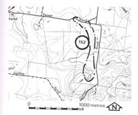
152A/B. Kernot - Tertiary Gravels
|
This information has been developed from one or more of these publications:
|
Location: | Grantville - 781457 and 790445. Road cutting and small quarry two kilometres east of Kernot. | |
Access: | Kernot Road and Garys Road. | |
Ownership: | Crown Land (road cutting) and private land. | |
Geology: | Exposed at these sites are sand and gravels containing clay clasts that are derived from weathering of the underlying basalt. In the road cutting are pebbles of reef quartz and quartzite. | |
Significance: | Regional. The exposures provide a basis for subdivision of the Tertiary sediments in the Kernot area. | |
Management: | Future roadworks or quarrying operations should be designed to maintain the exposures of the sediments. | |
References: | Tickell, S.J., 1971. The geology of the Bass River Area. B.Sc. Hons thesis (unpub.) Dept. of Geol. Univ. of Melb. Spencer-Jones, D., Marsden, M.A.H., Barton, C.M. & Carrillo-Rivera, J.J., 1975. Geology of the Western Port sunkland. Proc. Roy. soc. Vict. (87) 1&2, 43-68. | |


