120. Poowong - Valley Capture
|
This information has been developed from one or more of these publications:
|
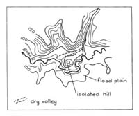
Location: | Nyora - 895535. Three kilometres north-east of Loch. |  Isolated hill (A), dry valley (arrow), Bass River floodplain (B). |
Access: | Loch - Poowong road. | |
Ownership: | Crown Land (Public Land Water Frontage Reserve) and private land. | |
Geology/Geomorphology: | A small spur of Mesozoic sandstone deflects the Bass River and the spur end is now an isolated hill. The isolation is due to capture by the river of the lower valley of a tributary creek that originally entered the Bass River 500 metres to the west. The Poowong to Loch road traverses this abandoned valley north of the isolated hill. | |
Significance: | Regional. The site illustrates a mechanism of the isolation of bedrock inliers in younger flood plain sediments. This is an exceptionally clear example of a stage in this process. | |
Management: | Class 3. Changes in land use will be unlikely to alter the significance of the features at the site. | |


