
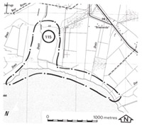
115. Pioneer Bay - Quaternary Stratigraphy
|
This information has been developed from one or more of these publications:
|
| Location: | Lang Lang - 715558. Two kilometres south-east of Red Bluff. | 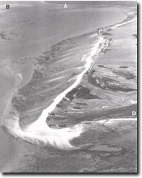 The multiple recurving spits that comprise Stockyard Point. Also shown are Lang Lang delta (A), tidal watershed (B), Red bluff (C), part of Pioneer Bay (D). |
Access: | Jetty Lane. | |
Ownership: | Crown land and private land. | |
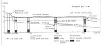
Geology/Geomorphology: | In Pioneer Bay a sequence of freshwater, marine and intertidal sediments record the late Quaternary sea level history of this part of Westernport Bay. Freshwater peats, organic muds, salt marsh clays and some sand and shells outcrop as low cliffs or can be recovered by shallow coring. Radiocarbon dating of the sediments has been used as a basis to interpret late Pleistocene sea level changes. The sequence has been described in detail and interpreted by Miles (1976). The present shoreline is an eroding low cliff backed by a degraded saltmarsh terrace. One hundred metres inland is an abandoned low cliff of similar form to the active one but cut into older freshwater swamp deposits. | |
Significance: | International. This is the best documented and dated site in the Westernport region to contribute to an understanding of late Quaternary sea level changes. It therefore constitutes a site of international significance as part of the growing network of such localities on the Australian coast. These sites are of interest to Quaternary scientists attempting to elucidate the nature of sea level changes on different continents. | |
Management: | Class 1. The surface and sub-surface sediments and the configuration of the present and former shorelines are the critical components of the site. Therefore no construction works or excavations of any kind should be permitted as these will interfere with the display of these elements of the site. Grazing animals should be excluded from the site as these cause deterioration of the land surface form. | |
References: | Miles, I. W. (1976). The morphology of northern Westernport Bay. M.Sc. thesis (unpub.) Dept. of Geog. Univ. of Melb. | |

© State of Victoria (Agriculture Victoria) 1996 - .

This work, Victorian Resources Online, is licensed under a Creative Commons Attribution 4.0 licence. You are free to re-use the work under that licence, on the condition that you credit the State of Victoria (Agriculture Victoria) as author, indicate if changes were made and comply with the other licence terms.
The licence does not apply to ‘branding’ or some ‘images or photographs’ that may be owned by third parties. We ask you to seek prior approval to use images using the VRO feedback form. Access to higher quality images can also be provided on request.
This page was last updated on .