
LP9
| Group: Middle Creek Landcare Group | Australian Soil Classification: Hypercalcic, Subnatric, Red SODOSOL |
| Northcote Factual Key:Dy 2.43 | Great Soil Group: solodized solonetz |
| General Landscape Description: Upper slope on western side of a sedimentary (lower Ordovician) hillslope. Yellow Gum (E. leucoxylon) and Grey Box (E. microcarpa) association is the typical native vegetation. | |
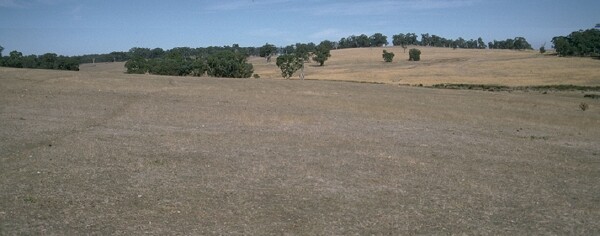 LP9 Landscape |
Soil Profile Morphology
Surface Soil
| A1 | 0-5 cm | Dark brown (10YR3/3) light fine sandy clay loam; weakly structured; firm consistence dry; contains occasional shale fragments; pH 5.5; sharp and irregular change to: | 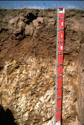 LP9 Profile |
| A2 | 5-10 cm | Light brown (7.5YR6/4) conspicuously bleached fine sandy clay loam; weakly structured; strong consistence dry; contains a slight (10%) amount of ferruginous nodules (buckshot); pH 6.5; sharp and irregular change to: | |
| Subsoil | |||
| B21 | 10-25 cm | Yellowish Red (5YR5/8) heavy clay; moderate coarse columnar, breaking down to strong coarse blocky structure (with smooth faced peds); very strong consistence moist; contains occasional shale fragments; pH 7.1; sharp and wavy change to: | |
| B22 | 25-40 cm | Red (2.5YR4/8) heavy clay; strong medium blocky structure; very strong consistence moist; contains occasional shale fragments; pH 8.6 : | |
| B3k | 40-100 cm | Strong brown (7.5YR4/6) medium clay; with a heavy (>50%) amount of soft carbonate together with weathered shale; pH 9.3; gradual change to: | |
| C | 100+ cm | Laminated soft shale. | |
Key Profile Features
- Strong textural contrast between A horizon and clay B horizons.
- Sodic subsoil.
- Increasing pH with depth down the profile.
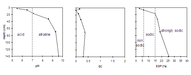
Key Profile Characteristics
pH | Salinity Rating | |||
Surface (A1 horizon) | strongly acid | very low | non-sodic | water-stable |
Subsoil (B21 horizon) | slightly alkaline | very low | sodic | strong |
Deeper subsoil (at 1 m) | very strongly alkaline | low | strongly sodic | strong |
 |
Management Considerations:
Surface (A) horizons
- The surface horizon has high levels of organic carbon and total nitrogen and a moderate overall nutrient status. However, being very shallow (i.e. 5 cm deep) it provides a limited rooting environment above the sodic subsoil.
- The high organic matter levels ensure that the surface aggregates are water-stable and will not readily break down when wet.
- Aluminium and manganese toxicity can occur in strongly acid surface soils, although exchangeable aluminium and manganese levels appear relatively low at this site. A lime test (sampled at the paddock level) may be appropriate to determine whether lime is needed to raise the pH levels.
- The conspicuously bleached A2 horizon indicates that periodic waterlogging may occur. This horizon has low fertility and is likely to become "soupy" when worked in a wet condition (as is evident by strong dispersion occurring after remoulding).
Subsoil (B) Horizons
- The coarsely structured and dense subsoil (i.e. B21 horizon) is sodic and becomes strongly sodic with increasing depth down the profile. Strong dispersion occurs as a result, creating conditions which will restrict water and plant root movement.
- Effective plant rooting depth is shallow due to the coarsely structured sodic subsoil being encountered at 10 cm depth. Plant available water capacity for the profile is also low as a consequence.
- At a depth of 40 cm the soil becomes strongly alkaline which may result in nutrients such as phosphorous, iron, manganese and zinc becoming poorly available to plants.
© State of Victoria (Agriculture Victoria) 1996 - 2025.

This work, Victorian Resources Online, is licensed under a Creative Commons Attribution 4.0 licence. You are free to re-use the work under that licence, on the condition that you credit the State of Victoria (Agriculture Victoria) as author, indicate if changes were made and comply with the other licence terms.
The licence does not apply to ‘branding’ or some ‘images or photographs’ that may be owned by third parties. We ask you to seek prior approval to use images using the VRO feedback form. Access to higher quality images can also be provided on request.
This page was last updated on 24/06/2020.