
LP84
| Group: Raywood Farm Advance Group | Australian Soil Classification: Eutrophic, Subnatric, Grey SODOSOL |
| Northcote Factual Key:Dg/Dy | Great Soil Group: no suitable group |
| General Landscape Description: Old alluvial plain with prior stream activity. This soil occurs on north-south trending strips throughout the area which probably relate to prior stream channel deposits. Original vegetation included Grey Box (Eucalyptus microcarpa) and Buloke (Casuarina luehmannii). | |
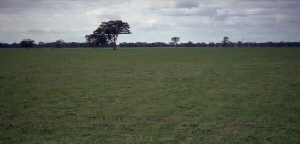 LP84 Landscape |
Soil Profile Morphology
Surface Soil
| A1 | 0-10 cm | Dark reddish brown (5YR3/4); heavy sandy loam; moderate medium blocky structure; firm consistence dry; pH 5.9; sharp change to: | 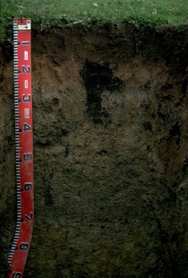 LP84 Profile |
| A2 | 10-30 cm | Yellowish red (5YR5/6); coarse loamy sand; firm consistence dry; structureless; pH 7.1; clear change to: | |
| Subsoil | |||
| B1 | 30-40 cm | inkish grey (7.5YR7/2) conspicuously bleached; light sandy clay loam; structureless; pH 7.7; clear change to: | |
| B2 | 40-50 cm | Pinkish grey (7.5YR7/2) (with patches of light grey (2.5Y7/2); light medium clay (sandy); breaks down to moderate very fine polyhedral structure; strong consistence dry; contains very few (<2%) ferruginous (ironstone) nodules; pH 7.6; abrupt change to: | |
| 2A1 | 50-52 cm | Pale brown (10YR6/3); fine sandy loam; structureless; strong consistence dry; discontinuous across pit face; contains many (20%) mainly quartz gravels (2-5 mm size); pH 7.6; abrupt change to: | |
| 2B21 | 52-70 cm | Yellowish brown (10YR5/6) with reddish brown (5YR5/4) mottles; medium clay (sandy); moderate coarse blocky, breaking down to strong very fine polyhedral structure; contains very few (<2%) ironstone nodules (1-2 cm diameter) and many (20%) quartz fragments (4-5 mm diameter); pH 7.7; sharp change to: | |
| 2B22 | 70+ cm | Brownish yellow (10YR6/6), yellowish brown (10YR5/4) and yellowish red (5YR5/8); light clay (sandy); indurated; strong medium polyhedral structure; contains few (5%) quartz gravels (2-5 mm diameter); pH 8.5. | |
Key Profile Features
- Buried soil horizons occur due to alluvial deposition.
- Indurated (i.e. hardened) subsoil horizons.
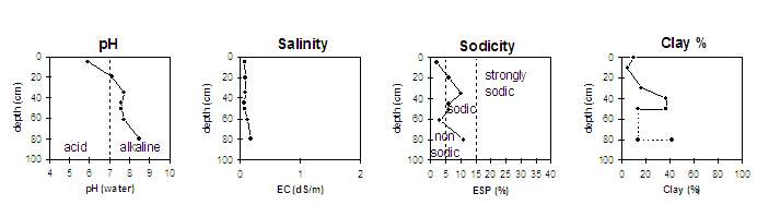
Key Profile Characteristics
pH | Salinity Rating | |||
Surface (A1 horizon) | moderately acid | very low | non-sodic | none |
Subsoil (B21 horizon) | slightly alkaline | very low | sodic | moderate-strong |
Deeper subsoil (at 70+ cm) | moderately alkaline | very low-low | sodic | none1 |
| 1 Moderate dispersion after remoulding. | ||||
 |
Horizon | Horizon Depth | pH (water) | pH CaCl2 | EC 1:5 | NaCl | Exchangeable Cations | |||
Ca | Mg | K | Na | ||||||
meq/100g | |||||||||
A1 | 0-10 | 5.9 | 5 | 0.07 | 4.2 | 0.6 | 0.6 | 0.1 | |
A2 | 10-30 | 7.1 | 6.5 | 0.09 | 1.3 | 0.2 | 0.3 | 0.1 | |
B1 | 30-40 | 7.7 | 6.6 | 0.09 | 2 | 1.6 | 0.3 | 0.4 | |
B2 | 40-50 | 7.6 | 6.5 | 0.06 | 6.4 | 5.3 | 0.8 | 0.8 | |
2A1 | 50-52 | 7.6 | 6.6 | 0.07 | 2.5 | 2.4 | 0.5 | 0.3 | |
2B21 | 52-70 | 7.7 | 6.5 | 0.12 | 7.2 | 2.8 | 1.2 | 0.3 | |
2B22 | 70+ | 8.5 | 7.3 | 0.17 | 5.9 | 11 | 1.2 | 2.3 | |
Horizon | Horizon Depth | Ex Al mg/kg | Ex Ac meq/100g | Field pF2.5 | Wilting Point pF4.2 | Coarse Sand (0.2-2.0mm) | Fine Sand (0.02-0.2mm) | Silt (0.002-0.02mm) | Clay (<0.002mm) |
A1 | 0-10 | 11.9 | 3.9 | 37 | 40 | 11 | 10 | ||
A2 | 10-30 | 9.3 | 1.9 | 41 | 44 | 10 | 5 | ||
B1 | 30-40 | 12.7 | 4.7 | 36 | 36 | 13 | 16 | ||
B2 | 40-50 | 24.1 | 12.8 | 26 | 27 | 9 | 37 | ||
2A1 | 50-52 | 19 | 41 | 17 | 14 | ||||
2B21 | 52-70 | ||||||||
2B22 | 70+ |
Management Considerations:
Whole Profile
- Plant Available Water Capacity (PAWC) is estimated to be relatively low (approximately 52 mm) for this Site. This is based on available laboratory data and assumes an effective rooting depth of 50 cm. Rooting depth will be restricted by the indurated (hardened) deeper subsoil horizons.
- Soluble salt levels are very low throughout the profile.
Surface (A) Horizon
- The surface soil has relatively low levels of total nitrogen and organic carbon.
- The surface soil contains quartz gravel which will be abrasive to tillage implements.
- The surface soil is hardsetting and has a high fine sand (40%) content. Upon wetting and drying the surface soil will set hard and become difficult to work. It may become "powdery" when worked in a dry condition. Cultivation of such soils when wet may result in surface sealing upon drying. Tillage should be minimised and stubble retention/pasture rotations practised. Improving soil organic matter levels will assist in improving soil aggregation as well as improving fertility and water holding capacity.
- The water holding capacity of the surface horizons is relatively low. The low wilting point value indicates that plants will be able to utilise light rains falling on relatively dry soil.
- The subsurface (A2) horizon has a very low inherent fertility (based on the sum of the exchangeable cations). It will also become "spewy" when wet and set hard when dry.
Subsoil (B) Horizons
- The subsoil is sodic and disperses moderately to strongly in water. This is likely to restrict water and root movement into the subsoil. Waterlogging may result after heavy rains.
- From 50 cm depth, a number of the subsoil horizons are indurated (hardened). This is also likely to restrict water and root movement.
Comments from Landholder:
- This soil occurs on north-south trending strips through the area.
- Gypsum (1 tonne/acre) applied which improved drainage conditions.
- Deep tillage (agro plough) used.
- Abrasive to tillage implements.
- Clover, wheat rotation.
- Lucerne does not grow well.
- Not a good cropping soil.
Notes
- Profile described by Mark Imhof, Paul Rampant and Karen De Plater (4/7/95)
© State of Victoria (Agriculture Victoria) 1996 - 2025.

This work, Victorian Resources Online, is licensed under a Creative Commons Attribution 4.0 licence. You are free to re-use the work under that licence, on the condition that you credit the State of Victoria (Agriculture Victoria) as author, indicate if changes were made and comply with the other licence terms.
The licence does not apply to ‘branding’ or some ‘images or photographs’ that may be owned by third parties. We ask you to seek prior approval to use images using the VRO feedback form. Access to higher quality images can also be provided on request.
This page was last updated on 24/06/2020.