
LP83
| Group: Navarre and Districts Landcare Group | Map Sheet: ST ARNAUD |
| Aust. Soil Class.: Haplic, Mesotrophic, Red CHROMOSOL | Northcote Factual Key: Dr 2.21 |
| General Landscape Description: Crest of hill (11% slope) on Rolling Hills landform pattern. Original vegetation included Red Stringybark (Eucalyptus macrorhyncha). | |
| Geology: Cambrian sediments. (sandstone and slate). | |
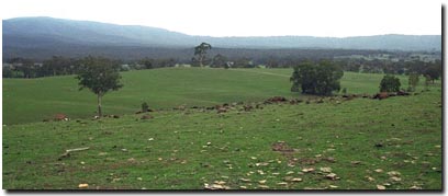 Soil Site LP 83 Landscape |
Soil Profile Morphology
Surface Soil
| A1 | 0-10 cm | Dark reddish brown (5YR3/3); sandy loam; weak medium blocky structure; very weak consistence dry; contains many (25%) sandstone fragments (7 mm average diameter); pH 5.7; abrupt change to: | 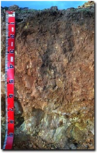 Soil Site LP83 Profile |
| A2 | 10-25 cm | Reddish brown (5YR4/4); fine sandy clay loam; weak medium blocky, parting down to moderate fine polyhedral structure; weak consistence dry; contains many (25%) fine sandstone fragments (10 mm average diameter); pH 6.2; clear change to: | |
| Subsoil | |||
| B1 | 25-60 cm | Yellowish red (5YR4/6); medium clay; moderate medium polyhedral, parting to strong fine polyhedral structure; firm consistence dry; contains very few (< 2%) soft and hard manganiferous segregations (6-8 mm diameter); and many (50%) fine sandstone fragments (up to 100 mm diameter); pH 5.9; gradual change to: | |
| BC | 60+ cm | Mainly sandstone (90%). Contains (10%) yellowish red (5YR5/8); medium clay; contains very few (<2%) soft and hard manganiferous segregations (6-8 mm diameter), and very many (90%) fine sandstone fragments. | |
Key Profile Features
- Strong texture contrast between surface (A) horizon and the upper subsoil (B21) horizon.
- Shallow soil profile.
Key Profile Characteristics
pH | Salinity Rating | |||
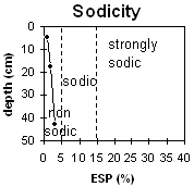
Surface (A1 horizon) | moderately acid | low | non-sodic | none1 |
Subsoil (B21 horizon) | moderately acid | very low | non-sodic | slight |
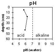 | 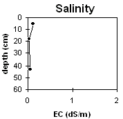 |  | |
Horizon | Horizon Depth | pH (water) | pH CaCl2 | EC 1:5 | NaCl | Exchangeable Cations | |||
Ca | Mg | K | Na | ||||||
Meq/100g | |||||||||
A1 | 0-10 | 5.7 | 4.9 | 0.11 | 7.7 | 2.2 | 0.6 | 0.1 | |
B1 | 10-25 | 6.2 | 5.3 | <0.05 | 3.5 | 1.8 | 0.4 | <0.1 | |
B21 | 25-60 | 5.9 | 4.9 | 0.04 | 0.6 | 2.9 | 0.3 | 0.1 | |
Horizon | Horizon Depth | Ex Al mg/kg | Ex Ac meq/100g | Field pF2.5 | Wilting Point pF4.2 | Coarse Sand (0.2-2.0mm) | Fine Sand (0.02-0.2mm) | Silt (0.002-0.02mm) | Clay (<0.002mm) |
A1 | 0-10 | 36.2 | 10.3 | 18 | 37 | 29 | 16 | ||
B1 | 10-25 | 27.5 | 7.9 | 11 | 41 | 29 | 18 | ||
B21 | 25-60 | 26.8 | 10.4 | 13 | 26 | 25 | 32 |
Management Considerations:
Whole Profile
- Plant available water capacity (PAWC) is likely to be quite low for soils such as these that are shallow and contain large amounts of coarse fragments.
- Exchangeable calcium levels are relatively high in the moderately acid surface horizon – suggesting that lime has been applied and that natural pH levels have been increased.
- Organic carbon and total nitrogen levels are reasonably high at this site. This is a good result as organic matter enhances the fertility, aggregate stability and water holding capacity of surface soils.
- The subsoil has a low inherent fertility (based on the sum of the exchangeable basic cations).
- The soil profile will be reasonably well draining and these areas are likely to be significant recharge areas.
- Improved pasture with Phalaris and Cocksfoot.
- Stocked at 11/2 - 2 sheep per acre.
- Lower in the landscape, this country is susceptible to erosion and salinity.
- Very deficient in potassium.
- Molybdenum applied with superphosphate every 7 years.
Profile described by Paul Rampant, Sonia Thompson and Ruth Lourey (5/6/95).
© State of Victoria (Agriculture Victoria) 1996 - 2025.

This work, Victorian Resources Online, is licensed under a Creative Commons Attribution 4.0 licence. You are free to re-use the work under that licence, on the condition that you credit the State of Victoria (Agriculture Victoria) as author, indicate if changes were made and comply with the other licence terms.
The licence does not apply to ‘branding’ or some ‘images or photographs’ that may be owned by third parties. We ask you to seek prior approval to use images using the VRO feedback form. Access to higher quality images can also be provided on request.
This page was last updated on 23/03/2020.