
LP7
This page is under construction and is not complete.
Key Profile Features:
Soil Profile Characteristics:
Surface (A) Horizons
Subsoil (B) Horizon
Surface (2A1) Horizon of a Buried Profile
Page top
| Location: Cohuna | Australian Soil Classification: |
| Northcote Factual Key: | Great Soil Group: |
| General Landscape Description: Flat plain. | Local Name: Cohuna Fine Sandy Loam. |
Soil Profile Morphology:
Surface Soil
| A11 | 0-10 cm | Brown (10YR4/3) with strong brown (7.5YR4/6) mottles; sandy clay loam; strong coarse blocky, breaking down to strong fine blocky structure; strong consistence dry; pH 7.5; sharp and smooth change to: | |
| A12 | 10-25 cm | Brown (10YR4/3) with strong brown (7.5YR5/6) mottles; fine sandy clay loam (silty); firm consistence dry; pH 8.9; sharp and smooth change to: | |
Subsoil | |||
| B21 | 25-50 cm | Strong brown (7.5YR4/6); heavy clay; moderate medium blocky structure; very firm consistence dry; contains a few (2%) soft carbonates and very few (<2%) hard carbonates as well as grey and black inclusions along root channels; pH 9.3; sharp and smooth change to: | |
| Surface Soil of a Buried Profile | |||
| 2A1 | 50-80 cm | Strong brown (7.5YR5/6); very fine sandy loam; structureless; weak consistence dry; contains fine mica; pH 9.5. | |
Key Profile Features:
- Strong texture contrast between surface (A) horizons (20% clay) and subsoil (B21) horizon (> 50 % clay).
- Accumulation of carbonates in the subsoil.
- Buried profile (i.e. one profile over the top of another profile).
Soil Profile Characteristics:
 |
Management Considerations:
Whole Profile
- A very positive feature of this profile is that it has a very high inherent fertility throughout which is beneficial to plant growth.
Surface (A) Horizons
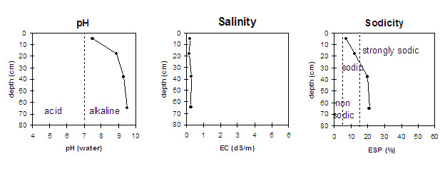
- The surface (A11) horizon is sodic with no dispersion after immersion in water. However, there is slight dispersion after the soil is remoulded and immersed in water. This indicates that some structural degradation may occur if cultivation occurs when the soil is wet.
- The levels of organic carbon measured at the pit site is low (this may or may not be representative of the whole paddock).
- The levels of total nitrogen measured at this pit site is moderate. However, this is best assessed by taking a bulked sample from across the paddock.
Subsoil (B) Horizon
- The subsoil (B21) is strongly sodic at 25 cm depth with a low exchangeable calcium to magnesium ratio (0.4) and strong dispersion after immersion in water. This indicates that root and water movement will be significantly restricted in the subsoil.
- The very strongly alkaline subsoil suggests that some nutrients (e.g. iron, manganese, zinc, copper) may be poorly available to plants and that deficiencies are likely to occur. Deficiencies can be determined by plant tissue analysis.
- Roots were found in the subsoil (25-50 cm depth).
Surface (2A1) Horizon of a Buried Profile
- The buried surface (2A1) horizon is strongly sodic with a low exchangeable calcium to magnesium ratio (0.7) and due to the moderate salinity level no dispersion.
© State of Victoria (Agriculture Victoria) 1996 - 2025.

This work, Victorian Resources Online, is licensed under a Creative Commons Attribution 4.0 licence. You are free to re-use the work under that licence, on the condition that you credit the State of Victoria (Agriculture Victoria) as author, indicate if changes were made and comply with the other licence terms.
The licence does not apply to ‘branding’ or some ‘images or photographs’ that may be owned by third parties. We ask you to seek prior approval to use images using the VRO feedback form. Access to higher quality images can also be provided on request.
This page was last updated on 23/03/2020.