
LP6
This page is under construction and is not complete.
| Location: Cohuna | Australian Soil Classification: |
| Northcote Factual Key: | Great Soil Group: |
| General Landscape Description: Flat plain. | Local Name: Kooroop Clay |
Soil Profile Morphology:
Surface Soil
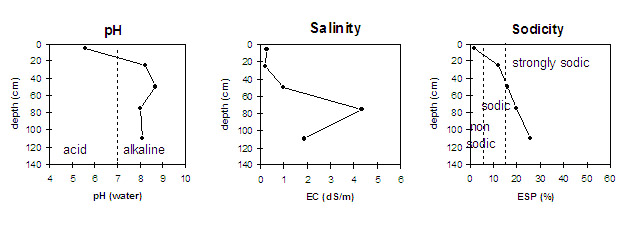
| A1 | 0-10 cm | Dark brown (10YR3/3) with dark greyish brown (10YR4/2) mottles; fine sandy clay loam; self mulching surface condition; granular structure; strong consistence dry; pH 5.8; sharp and smooth change to: | |
| Subsoil | |||
B21 | 10-40 cm | Brown (10YR4/3) [becomes a conspicuous bleach on drying (10YR7/2d)], also contains dark greyish brown (10YR4/2) infills; medium heavy clay; strong coarse prismatic, breaking down to strong coarse blocky structure; strong consistence dry; contains rusty root channel mottling; pH 8.2; gradual and smooth change to: | |
NOTE: The structure is platy in the top few centimetres. | |||
B22 | 40-60 cm | Brown (10YR4/3) with dark yellowish brown (10YR4/4) mottles; heavy clay; strong coarse blocky structure; very strong consistence; pH 8.7; gradual and smooth change to: | |
B23 | 60-90 cm | Light yellowish brown (10YR6/4); medium heavy clay; strong coarse lenticular structure; firm consistence wet; contains sulphates in the form of fish scale crystals as well as dark inclusions; pH 8.0; gradual and smooth change to: | |
B24 | 90+ cm | Yellowish brown (10YR5/6); medium clay; strong lenticular structure; weak consistence wet; contains dark inclusions; pH 8.1. | |
Key Profile Features:
- Self-mulching surface condition.
- Strong texture contrast between surface (A1) horizon (39% clay) and subsoil (B21) horizon (61% clay).
- Vertic properties (i.e. significant shrink-swell characteristics) in the subsoil.
Soil Profile Characteristics:
 |
Management Considerations:
Whole Profile
- A very positive feature of this profile is that it has a very high inherent fertility throughout which is benefical to plant growth.
Surface (A) Horizon
- The surface soil is self-mulching which provides a good seed bed that is friable and easily worked.
- The surface soil is non-sodic and does not disperse in water. However, there is moderate dispersion after remoulding the soil and immersing it in water. This indicates that some structural degradation may occur if cultivation occurs when the soil is wet.
- The high wilting point value (25%) indicates that plants will be unable to utilise light rains when the soil is relatively dry.
- The levels of organic carbon measured at the pit site are extremely high (this }ay or may not be representative of the whole paddock).
- The levels of total nitrogen measured at this pit site are extremely high. However, this is best assessed by taking a bulked sample from across the paddock.
Subsoil (B) Horizons
- The upper subsoil has a conspicuous bleach on drying indicating that periodic waterlogging occurs above the slowly permeable subsoil.
- The subsoil is densely and coarsely structured. The upper subsoil (B21) is sodic with a low exchangeable calcium to magnesium ratio (0.9) and disperses strongly after immersion in water. This indicates that if tillage occurs when this horizon is in a wet condition, a plough pan may develop. Interestingly platy structure was observed in the top few centimetres. The deeper subsoil (B22) becomes strongly sodic at 50 cm and with an extremely high salinity level at 60 cm, the dispersion decreases accordingly. However, root and water development may still be significantly restricted due to the lower porosity of these more clayey horizons.
- The subsoil displays strong vertic properties which indicates that significant shrinking and swelling occurs with wetting and drying cycles. This may disturb the roots of some plant species and has engineering implications (e.g. disturbance to building foundations and fence lines).
Profile Described By: John Martin and Mark Imhof (1994)
© State of Victoria (Agriculture Victoria) 1996 - 2025.

This work, Victorian Resources Online, is licensed under a Creative Commons Attribution 4.0 licence. You are free to re-use the work under that licence, on the condition that you credit the State of Victoria (Agriculture Victoria) as author, indicate if changes were made and comply with the other licence terms.
The licence does not apply to ‘branding’ or some ‘images or photographs’ that may be owned by third parties. We ask you to seek prior approval to use images using the VRO feedback form. Access to higher quality images can also be provided on request.
This page was last updated on 23/03/2020.