
LP5
| Location: Kerang East | Australian Soil Classification: |
| Northcote Factual Key: | Great Soil Group: |
| General Landscape Description: Flat plain. | Local Name: Swamp Type Soil. |
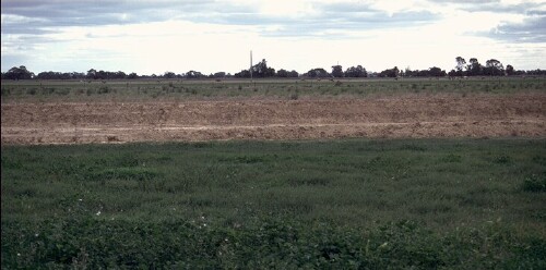
LP05 Landscape
Soil Profile Morphology:
Surface Soil
| A1 | 0-15 cm | Dark greyish brown (10YR4/2); medium heavy clay; strong coarse blocky structure; weak consistence moist; pH 7.7; clear and smooth change to: | 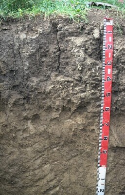 LP05 Profile |
| Subsoil | |||
| B21 | 15-40 cm | Greyish brown (10YR5/2); medium clay; strong coarse blocky, breaking down to strong medium blocky structure; weak consistence moist; pH 8.1; gradual and smooth change to: | |
| B22 | 40-65 cm | Light yellowish brown (10YR6/4); light medium clay; firm consistence moist; pH 8.3; gradual and smooth change to: | |
| B23 | 65+ cm | Brownish yellow (10YR6/6); light clay; strong coarse prismatic, breaking down to strong fine blocky structure (contains some lenticular peds); weak consistence moist; contains very few (<2%) manganese concretions and a few (2-10%) carbonates; pH 8.2. | |
Key Profile Features:
- High clay content throughout profile.
- Vertic properties (i.e. significant shrink-swell characteristics).
Soil Profile Characteristics:
 |
Management Considerations:
Whole Profile
- A very positive feature of this profile is that it has a very high inherent fertility throughout which is benefical to plant growth.
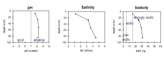
- The high to extremely high salinity in this profile is likely to restrict the growth of salt sensitive plant species (e.g. faba beans, linseed, chickpeas and lupins).
Surface (A) Horizon
- The surface (A1) horizon is strongly sodic and disperses moderately after the soil is remoulded and immersed in water. This indicates that structural degradation (e.g. surface sealing, increased cloddiness) may occur if the soil is cultivated or overstocked in a moist to wet condition. Also, raindrop action on bare surface soil may also promote dispersion and result in surface sealing or surface crust formation. Surface cover should be maintained to protect against raindrop damage. The use of gypsum may assist in ameliorating the surface soil.
- The high wilting point value (22%) indicates that plants will be unable to utilise light rains when the soil is relatively dry.
- The levels of total nitrogen measured at this pit site is moderate. However, this is best assessed by taking a bulked sample from across the paddock.
- The levels of organic carbon measured at the pit site is low (this may or may not be representative of the whole paddock).
Subsoil (B) Horizons
- The densely and coarsely structured subsoil (B21) is strongly sodic with a low exchangeable calcium to magnesium ratio (0.7) and moderate dispersion after remoulding. This indicates that root and water movement may be significantly restricted. The dispersion decreases with depth probably due to the extremely high salt levels.
- The high level of exchangeable sodium and magnesium in the deeper subsoil (50+ cm) may also result in nutrient imbalances and may also have a toxic effect on some plants.
- The subsoil displays vertic properties which indicates that significant shrinking and swelling occurs with wetting and drying cycles. This may disturb the roots of some plant species and has engineering implications (e.g. disturbance to building foundations and fence lines).
Profile Described By: John Martin, Mark Imhof and Sonia Thompson (1994)
© State of Victoria (Agriculture Victoria) 1996 - 2025.

This work, Victorian Resources Online, is licensed under a Creative Commons Attribution 4.0 licence. You are free to re-use the work under that licence, on the condition that you credit the State of Victoria (Agriculture Victoria) as author, indicate if changes were made and comply with the other licence terms.
The licence does not apply to ‘branding’ or some ‘images or photographs’ that may be owned by third parties. We ask you to seek prior approval to use images using the VRO feedback form. Access to higher quality images can also be provided on request.
This page was last updated on 23/03/2020.