
LP44
| Property: State Forest | Geo. Ref: 701955E, 5909000N; ST ARNAUD |
| Aust. Soil Class.: Bleached, Magnesic, Red KUROSOL | Northcote Factual Key: Dr 3.41 |
| Great Soil Group: red soloth | Geology: Cambrian sediments. |
| General Landscape Description: Mid to upper slope (slope 20%) on mountain ridge located approximately 5 km east of Barkly. Vegetation includes Grey Box (E. microcarpa) and Red Stringybark (E. macrorhyncha). | |
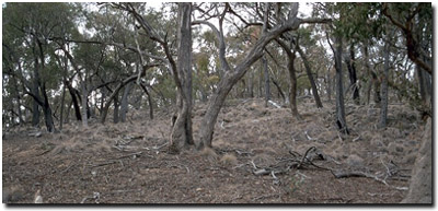 Soil Site LP 44 Landscape |
Soil Profile Morphology
Surface Soil
| A1 | 0-10 cm | Brown (7.5YR4/2); fine sandy loam; weak medium blocky structure; firm consistence dry; pH 5.0: | 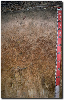 Soil Site LP44 Profile |
| A2 | 10-20 cm | Yellowish brown (10YR5/4) conspicuously bleached; fine sandy clay loam; structureless; contains very many (50%) angular quartz fragments; pH 5.1: | |
| Subsoil | |||
| B1 | 20-30 cm | Yellowish red (5YR5/8) and reddish yellow (5YR6/6); light medium clay; moderate medium to coarse polyhedral structure; strong consistence dry; pH 5.4: | |
| B21 | 30-60 cm | Dark red (2.5YR4/8); medium clay; strong medium to fine blocky structure; strong consistence dry; quartz floaters occur throughout; pH 5.4: | |
| B22 | 60-90 cm | Dark red (2.5YR4/8) and brownish yellow (10YR6/6); medium clay; strong medium to fine blocky structure; strong consistence dry; pH 5.6: | |
| C | 90 cm + | Weathered siltstone. | |
Key Profile Features
- Strong texture contrast between surface (A) horizons and subsoil (B21) horizon.
Key Profile Characteristics
pH | Salinity Rating | |||
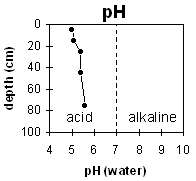
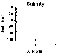
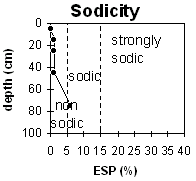
Surface (A1 horizon) | strongly acid | very low | non-sodic | none |
Subsoil (30 - 60 cm) | strongly acid | very low | non-sodic | none |
Deeper subsoil (60 - 90 cm) |
 |  |  | |
Horizon | Horizon Depth | pH (water) | pH CaCl2 | EC 1:5 | NaCl | Exchangeable Cations | |||
Ca | Mg | K | Na | ||||||
Meq/100g | |||||||||
A1 | 0-10 | 5 | 4.2 | 0.07 | 4.4 | 1.9 | 0.6 | 0.1 | |
A2 | 10-20 | 5.1 | 4 | <0.05 | 0.1 | 0.5 | 0.2 | 0.1 | |
B1 | 20-30 | 5.4 | 4.2 | <0.05 | 0.1 | 2 | 0.4 | 0.1 | |
B21 | 30-60 | 5.4 | 4.2 | <0.05 | 0.1 | 4 | 0.5 | 0.2 | |
B22 | 60-90 | 5.6 | 4.3 | <0.05 | <0.1 | 4.6 | 0.4 | 0.3 | |
C | 90 | ||||||||
Horizon | Horizon Depth | Ex Al mg/kg | Ex Ac meq/100g | Field pF2.5 | Wilting Point pF4.2 | Coarse Sand (0.2-2.0mm) | Fine Sand (0.02-0.2mm) | Silt (0.002-0.02mm) | Clay (<0.002mm) |
A1 | 0-10 | 87 | 23.2 | ||||||
A2 | 10-20 | 159 | 9.4 | ||||||
B1 | 20-30 | 187 | 11.2 | ||||||
B21 | 30-60 | 304 | 15.6 | ||||||
B22 | 60-90 | ||||||||
C | 90 |
Management Considerations:
Whole Profile
- Exchangeable aluminium levels are high throughout the strongly acid soil profile (increasing with depth). These levels will significantly restrict the growth of aluminium-sensitive plant species.
- The surface horizons have a low inherent fertility (based on the sum of the exchangeable basic cations).
- Exchangeable magnesium levels are high (ie. greater than 80% of total cations) throughout the subsoil. This may result in nutrient imbalances (e.g. calcium and potassium deficiency).
- Profile described by Mark Imhof, Paul Rampant and Karen De Plater (23/3/95).
© State of Victoria (Agriculture Victoria) 1996 - 2025.

This work, Victorian Resources Online, is licensed under a Creative Commons Attribution 4.0 licence. You are free to re-use the work under that licence, on the condition that you credit the State of Victoria (Agriculture Victoria) as author, indicate if changes were made and comply with the other licence terms.
The licence does not apply to ‘branding’ or some ‘images or photographs’ that may be owned by third parties. We ask you to seek prior approval to use images using the VRO feedback form. Access to higher quality images can also be provided on request.
This page was last updated on 23/03/2020.