
LP17
Location: Myall
Australian Soil Classification:
General Landscape Description: Flat moor.
Site Description: Irrigated pasture.
Local Soil Name: Swamp Clay.
Soil Profile Morphology
Surface Soil
| NOTE: This profile is truncated i.e. the surface soil (A1) has been removed. | |||
Subsoil | |||
| B21 | 0-80 cm | Grey (10YR5/1) with a conspicuous bleach (10YR7/2d), fine rusty root channel mottling; heavy clay; the surface condition is heavily cracked; very strong coarse prismatic, breaking down to moderate coarse polyhedral structure; very strong consistence dry; slightly calcareous; pH 6.5; clear change to: | |
| B22 | 80-120 cm | Grey (10YR5/1) with yellow (10YR7/6) mottles; heavy clay; strong coarse blocky, breaking down to fine lenticular structure; very firm consistence moist; contains few (2-10%) soft and hard carbonate nodules (10 mm in size); slightly calcareous; pH 8.5; clear change to: | |
| B23 | 120+ cm | Light brownish grey (2.5Y6/2); heavy clay; strong coarse lenticular, breaking down to strong fine lenticular structure; very firm consistence moist; contains very few (<2%) soft and hard carbonate nodules (10 mm in size) as well as a few (2-10%) very fine soft dark segregations; pH 8.4. | |
Key Profile Features:
- Truncated profile i.e. no surface (A1) soil.
- Cracked surface condition.
- High clay content in subsoil.
- Accumulation of carbonates within the subsoil.
- Vertic properties (i.e. significant shrink-swell characteristics).
pH | Salinity Rating | |||
Upper Subsoil (B21 horizon) | Slighly Acid | Very Low | Non-Sodic | None1 |
Subsoil (B22 horizon) | Moderately Alkaline | Low | Sodic | None2 |
Deeper Subsoil (at 120+ cm) | Moderately Alkaline | Low | Sodic | Slight |
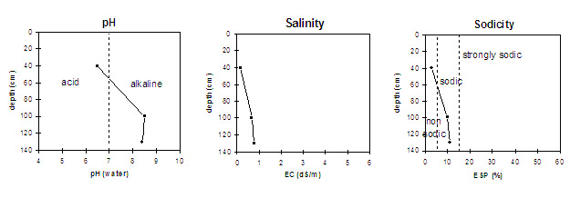
| The upper subsoil is slightly acidic. The deeper subsoil is moderately alkaline. | The salinity rating is low throughout the profile. | The upper subsoil is non-sodic. The deeper subsoil is sodic. |
Horizon | Horizon Depth (cm) | pH (water) | pH (CaCl2) | EC dS/m | Total Nitrogen % | Organic Carbon % | Exchangeable Cations | Field Capacity pF2.5 | Wilting Point pF4.2 | |||
Ca | Mg | K | Na | |||||||||
meq/100g | ||||||||||||
Truncated A1 | - | |||||||||||
B21 | 0-80 | 6.5 | 5.8 | 0.17 | 0.14 | 1.5 | 9.6 | 7.3 | 1.2 | 0.5 | 30.4 | 21.8 |
B22 | 80-120 | 8.5 | 7.9 | 0.66 | 11.2 | 11.1 | 1.0 | 2.4 | 35.3 | 22.5 | ||
B23 | 120+ | 8.4 | 7.9 | 0.76 | 9.9 | 14.1 | 0.9 | 2.9 | ||||
Management Considerations:
Whole Profile
- A positive feature of the subsoil is that it has a moderate inherent fertility becoming high with depth. This is beneficial to plant growth.
Upper Subsoil (B21) Horizon
- When the soil is dry, heavy rains will move down soil cracks (10 inches deep). This rapid recharge can be valuable for the survival of plants near wilting. When wet, the soil will swell and further infiltration will be relatively slow.
- Tillage of cracking clay soils should be avoided if the soil is wet (i.e. wetter than the plastic limit). At such a moisture condition, excessive tillage, trafficking or overstocking can result in structural degradation (e.g. compaction, smearing) occurring. Ideally, tillage should take place on clay soils such as these when the soil is drier than the plastic limit, down to at least the tillage depth.
- The presence of a conspicuous bleach indicates that periodic waterlogging occurs due to the heavy clay profile.
- The densely and coarsely structured upper subsoil is non-sodic and does not disperse in water. However, there is complete dispersion after the soil is remoulded and immersed in water. This indicates that some structural degradation may occur if cultivation occurs when the soil is wet.
- The levels of organic carbon measured at the pit site is low (this may or may not be representative of the whole paddock).
- The levels of total nitrogen measured at this pit site is moderate. However, this is best assessed by taking a bulked sample from across the paddock.
Deeper Subsoil (B22 and B23) Horizons
- The densely and coarsely structured deeper subsoil is sodic with a low exchangeable calcium to magnesium ratio (0.7). The moderate salinity level has probably contributed to the decrease in dispersion to nil (with only slight dispersion after remoulding) and is not likely to restrict water movement as significantly as would occur if the soil was not saline. Nevertheless, subsoil permeability will be low due to the low porosity of the clayey horizons.
- The subsoil displays vertic properties (i.e. lenticular structure etc.) which indicates that significant shrinking and swelling occurs with wetting and drying cycles. This may disturb the roots of some plant species and has engineering implications (e.g. disturbance to building foundations and fence lines).
Comments from Landholder:
- The site has been heavily laser graded and ripped for the purpose of irrigated pasture and thus top soil is limited.
- The landholder states that the site is alright for cropping, however, small plants find it hard to break through the surface. Gypsum keeps the surface friable and increases both water infiltration and crop immergence.
- Once the soil is wet it stays wet for a long period (this is due to the high clay content).
© State of Victoria (Agriculture Victoria) 1996 - 2025.

This work, Victorian Resources Online, is licensed under a Creative Commons Attribution 4.0 licence. You are free to re-use the work under that licence, on the condition that you credit the State of Victoria (Agriculture Victoria) as author, indicate if changes were made and comply with the other licence terms.
The licence does not apply to ‘branding’ or some ‘images or photographs’ that may be owned by third parties. We ask you to seek prior approval to use images using the VRO feedback form. Access to higher quality images can also be provided on request.
This page was last updated on 23/03/2020.