
LP123
| Group: Bendigo Creek Floodplain Group | Australian Soil Classification: Hypocalcic, Mottled-Subnatric, Brown SODOSOL |
| Northcote Factual Key:Db 2.23 | Great Soil Group: red-brown earth |
| General Landscape Description: Level plain. | Geology: Alluvial deposits (Quaternary). Shepparton Formation. |
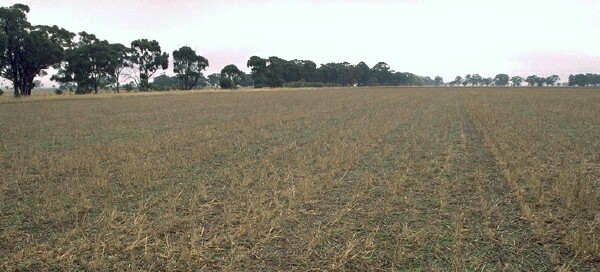 LP123 Landscape |
Soil Profile Morphology
Surface Soil
| A1 | 0-10 cm | Dark brown (7.5YR3/4), fine sandy loam; weakly structured; firm consistence when moderately moist; pH 6.1; abrupt change to: |  LP123 Profile |
| A2 | 10-20 cm | Strong brown (7.5YR4/6) and dark brown (7.5YR3/4) with a light brown (7.5YR6/4) mottle, sandy clay loam; very firm consistence when moderately moist; very few (2%) ferruginous nodules; pH 6.5; abrupt change to: | |
| Subsoil | |||
| B21 | 20-60 cm | Strong brown (7.5YR4/6) with a brownish yellow (10YR6/6) mottle, light medium clay; moderate coarse polyhedral structure, breaking to strong fine polyhedral structure; very firm consistence when moist; very few manganese stains; pH 8.2; clear change to: | |
| B22 | 60-90 cm | Yellowish red (5YR5/6) and yellowish brown (10YR5/8); light clay; moderate coarse polyhedral structure, breaking to strong fine polyhedral structure; very firm consistence when moist; very few manganese stains; very few ferromanganiferrous nodules; pH 8.8; gradual change to: | |
| B23 | 90-130 cm | Yellowish red (5YR5/6) and yellowish brown (10YR5/8) with a pale brown (10YR6/3) mottle, light clay; strong coarse polyhedral structure, breaking to strong fine polyhedral structure; very firm consistence when moist; very few soft and hard carbonates; trace of manganese stains; pH 9.1. | |
Key Profile Features
- Texture contrast between surface (A) horizon and subsurface (B) horizons.
Key Profile Characteristics
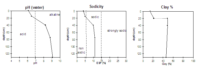
pH | Salinity Rating | |||
Surface (A1 horizon) | slightly acid | very low | non sodic | none1 |
Subsoil (B21 horizon) | moderately alkaline | very low | sodic | moderate |
Deeper subsoil (at 85+ cm) | very strongly alkaline | very low | sodic | strong |
| 1 slight dispersion after remoulding the aggregate. | ||||
 |
Management Considerations:
Surface (A) Horizons
- The surface horizon has a low inherent fertility (based on the sum of the basic exchangeable cations).
- The low wilting point (< 7%) for the surface horizons indicates that moisture will bet available for plant uptake after relatively light rains.
- Organic carbon levels show that organic matter content is low for the surface soil from this pit. Organic matter is important for enhancing soil aggregation, fertility and water holding capacity on soils such as these with a high fine sand content. Organic matter levels will build up under pasture but will decline if cultivation takes place. Practices such as residue retention, minimum tillage and including pasture rotations should be utilised if cropping occurs.
Subsoil (B) Horizons
- The subsoil is sodic and dispersive which will result in restricted root and water movement in the soil. Water is likely to build up on the surface and in the surface horizons (as it is more porous) after heavy rains causing waterlogging and surface runoff.
- The deeper subsoil (from 60 cm depth) is strongly alkaline which indicates that some nutrients (eg. copper, iron, manganese, and zinc) may be poorly available to deeper rooted plants.
Comments from Landholder:
- Wheat crop grown last year.
- Canola crop three years ago thought to yield poorly due to waterlogging.
Notes
- Profile described by Paul Rampant and Ruth Lourey (24/5/96)
© State of Victoria (Agriculture Victoria) 1996 - 2025.

This work, Victorian Resources Online, is licensed under a Creative Commons Attribution 4.0 licence. You are free to re-use the work under that licence, on the condition that you credit the State of Victoria (Agriculture Victoria) as author, indicate if changes were made and comply with the other licence terms.
The licence does not apply to ‘branding’ or some ‘images or photographs’ that may be owned by third parties. We ask you to seek prior approval to use images using the VRO feedback form. Access to higher quality images can also be provided on request.
This page was last updated on 23/03/2020.