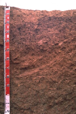
LP122
| Group: Bendigo Creek Floodplain Group | Australian Soil Classification: Hypercalcic, Subnatric, Red SODOSOL |
| Northcote Factual Key:Dr 2.13 | Great Soil Group: red-brown earth |
| General Landscape Description: Level Plain. | Geology: Alluvial deposits (Quaternary). Coonambidgal Formation. |
Soil Profile Morphology
Surface Soil
| A1 | 0-10 cm (to 25 cm in some places) | Dark reddish brown (5YR3/4), sandy clay loam; very firm consistence when moderately moist; pH 6.2; sharp change to: |  LP122 Profile |
| Subsoil | |||
| B21 | 10-30 cm | Dark reddish brown (5YR3/3), medium clay; moderate coarse blocky structure; very firm consistence when moderately moist; pH 7.7; gradual change to: | |
| B22 | 30-80 cm | Yellowish red (5YR4/6), medium clay; moderate coarse polyhedral structure; firm consistence when moist; pH 8.9; clear and wavy change to: | |
| Bk | Band of carbonates, soft and hard runs diagonally across profile from 35cm to 100cm. | ||
| B23 | 80-120 cm | Dark brown (10YR4/3) with yellowish red (5YR4/6 & 5YR5/8) mottles, light medium clay; moderate coarse polyhedral structure breaking to strong fine polyhedral structure; very firm consistence when moist; gypsum crystals present in top 10 cm of this horizon; occasional hard carbonate; pH 9.1. | |
Key Profile Features
- Texture contrast between surface (A) horizon and subsurface (B) horizons.
- Carbonate band (10 cm) runs roughly diagonally across the pit face from about 35 cm to 100 cm depth.
Key Profile Characteristics
pH | Salinity Rating | |||
Surface (A1 horizon) | slightly acid | very low | sodic | moderate dispersion1 |
Subsoil (B21 horizon) | slightly alkaline | very low | sodic | slight dispersion1 |
Deeper subsoil (at 80 cm) | strongly alkaline | very low | sodic | none1 |
| 1 Strong to complete dispersion when the aggregate is remoulded. | ||||
 |
Management Considerations:
Whole Profile
- The whole profile is sodic and dispersive which will result in restricted root and water movement in the soil. Water is likely to build up on the surface and in the surface horizon (as it is more porous) after heavy rains causing waterlogging and surface runoff. The addition of gypsum may ameliorate this problem. A test strip could be used to assess the likely benefits.
Surface (A) Horizons
- The surface horizon has a low inherent fertility (based on the sum of the basic exchangeable cations).
- Organic carbon levels show that organic matter content is low for the surface soil from this pit. Organic matter is important for enhancing soil aggregation, fertility and water holding capacity on soils such as these with such a high fine sand content. Organic matter levels will build up under pasture but will decline if cultivation takes place. Practices such as residue retention, minimum tillage and including pasture rotations should be utilised if cropping occurs.
Subsoil (B) Horizons
- Concentrated carbonate band (about 10 cm thick) runs diagonally across all horizons between 35 cm and 100 cm.
- The deeper subsoil (from 30 cm depth) is strongly alkaline which indicates that some nutrients (eg. copper, iron, manganese, and zinc) may be poorly available to deeper rooted plants.
Notes
- Profile described by Paul Rampant and Ruth Lourey (23/5/96)


