
LP119
| Group: Bendigo Creek Floodplain Group | Australian Soil Classification: Vertic (and Calcic), Mesonatric, Red SODOSOL |
| Northcote Factual Key:Dr 3.13 | Great Soil Group: red-brown earth |
| General Landscape Description: Level plain. | Geology: Alluvial deposits (Quaternary). Coonambidgal Formation. |
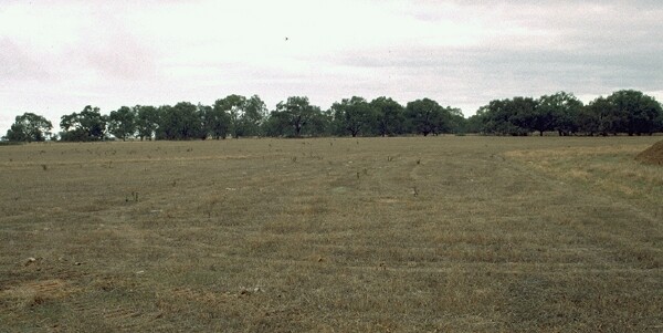 LP119 Landscape |
Soil Profile Morphology
Surface Soil
| A1 | 0-8 cm | Strong brown (10YR4/4) with dark yellowish brown (10YR4/4) mottle, fine sandy clay loam; weak structure; strong consistence when moderately moist; pH 6.6; sharp change to: | 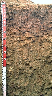 LP119 Profile |
| Subsoil | |||
| B21 | 8-35 cm | Dark reddish brown (5YR3/3), light medium clay; strong coarse blocky structure; strong consistence when moderately moist; slickensides evident from 30 cm; pH 7.8; gradual change to: | |
| B22 | 35-60 cm | Strong brown (7.5YR4/6), medium clay; moderate medium sized blocky structure; strong consistence when moderately moist; pH 8.8; abrupt change to: | |
| B23 | 60-70 cm | Dark yellowish brown (10YR4/6), light medium clay; moderate coarse blocky structure; strong consistence when moderately moist; few (10%) soft carbonates and gypsum crystals in pockets; pH 8.1; clear change to: | |
| B24 | 70-90 cm | Yellowish brown (10YR5/6) with dark yellowish brown (10YR4/6) mottle, medium clay; moderate coarse polyhedral structure, breaking to strong medium sized polyhedral structure; very firm consistence when moist; pH 8.3; gradual change to: | |
| B25 | 90-150 cm | Yellowish brown (10YR5/4) with yellowish red (5YR5/6) mottle, medium clay; weak coarse prismatic structure, breaking to moderate medium sized blocky structure, breaking to strong fine polyhedral structure; few (2%) soft and hard carbonates and very few manganese stains; pH 8.9. | |
Key Profile Features
- Shallow surface soil.
Key Profile Characteristics
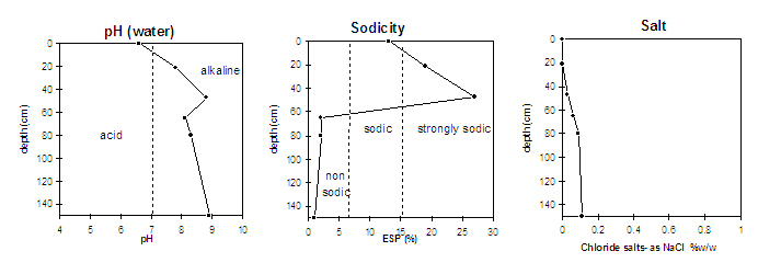
pH | Salinity Rating | |||
Surface (A1 horizon) | slightly acid | very low | sodic | slight1 |
Subsoil (B21 horizon) | slightly alkaline | low | strongly sodic | strong |
Deeper subsoil (at 90-150 cm) | strongly alkaline | low | non-sodic | none |
| 1 strong dispersion when remoulded. | ||||
 |
Management Considerations:
Surface (A) Horizon
- The surface horizon has a low inherent fertility (based on the sum of the basic exchangeable cations).
- The surface horizon sodic and dispersive when remoulded which will result in restricted water movement in the soil. Water is likely to build up on the surface causing waterlogging and surface runoff if the soil is worked in a moist condition. Dispersion may be caused by the action of raindrops on the soil surface; by retaining some stubble or cover this action is restricted. The reapplication of gypsum may also help alleviate this problem.
- Organic carbon levels show that organic matter content is low for the surface soil from this pit. Organic matter is important for enhancing soil aggregation, fertility and water holding capacity. Organic matter levels will build up under pasture but will decline if cultivation takes place. Practices such as residue retention, minimum tillage and including pasture rotations should be utilised if cropping occurs.
Subsoil (B) Horizons
- Upper horizons of the subsoil are strongly sodic and dispersive which will result in restricted root and water movement in the subsoil. Water is likely to build up on the surface and in the surface horizons (as they are more porous) after heavy rains causing waterlogging and surface runoff.
- The deeper subsoil (from 35 cm depth) is strongly alkaline which indicates that some nutrients (eg. copper, iron, manganese, and zinc) may be poorly available to deeper rooted plants.
Comments from Landholder:
- Gypsum applied four years ago (mixture of pit gypsum and manufactured gypsum).
- Safflower was grown here about 10 years ago (not too successful).
Notes
- Profile described by Paul Rampant and Ruth Lourey (23/5/96)
© State of Victoria (Agriculture Victoria) 1996 - 2025.

This work, Victorian Resources Online, is licensed under a Creative Commons Attribution 4.0 licence. You are free to re-use the work under that licence, on the condition that you credit the State of Victoria (Agriculture Victoria) as author, indicate if changes were made and comply with the other licence terms.
The licence does not apply to ‘branding’ or some ‘images or photographs’ that may be owned by third parties. We ask you to seek prior approval to use images using the VRO feedback form. Access to higher quality images can also be provided on request.
This page was last updated on 23/03/2020.