
LP11
| Group: Middle Creek Landcare Group | Australian Soil Classification: Vertic (and Hypocalcic), Mottled-Subnatric, Grey SODOSOL/ intermixed with Brown SODOSOL |
| Northcote Factual Key:Dg 2.43 | Great Soil Group: solodic |
| General Landscape Description: Upper slope of a slight rise on a gently undulating volcanic plain. In its original state it is likely that this country displayed gilgai microrelief (i.e. "crabholey country") which has since been levelled out by cultivation. | |
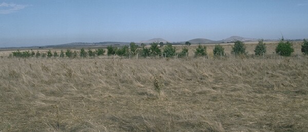 LP11 Landscape |
Soil Profile Morphology
Surface Soil
| A1 | 0-15 cm | Dark yellowish brown (10YR4/4); fine sandy clay loam; massive; very strong consistence dry; pH 5.4; sharp change to: | 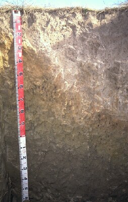 Lp11 Profile |
| A2 | 15-50 cm | Dark yellowish brown (10YR4/4) conspicuously bleached; fine sandy clay loam; massive; very firm consistence dry; contains a few (2-10%) soft iron and hard dark (manganese) segregations; pH 6.0; clear and irregular change to: | |
| Subsoil | |||
| B1 | 50-75 cm | Very pale brown (10YR7/3) and reddish yellow (7.5YR6/8) mottles; light clay; strong consistence dry; pH 6.5; clear change to: | |
| B21 | 75-90 cm | Pale brown (10YR6/3) with (10YR4/8) and brownish yellow (10YR6/6) mottles; medium heavy clay; strong coarse blocky, breaking down to strong fine blocky structure; firm consistence moist; pH 7.3; sharp change to: | |
| B31 | 90-110 cm | Light olive brown (2.5Y5/4) and brownish yellow (10YR6/8) diffuse mottles; heavy clay; moderate coarse prismatic, breaking down to strong coarse blocky structure; contains a common (10-15%) amount of soft dark (manganese) segregations; sharp change to: | |
| B32 | 110+ cm | Light olive brown (2.5Y5/4); heavy clay; strong consistence moist. | |
| Note: In areas where the deep irregular bleached horizon does not occur, the A2 horizon is about 5 cm deep and underlain by a 40 cm deep B21 horizon. The B21 is a yellowish brown (10YR5/6); medium clay; coarse prismatic, breaking down to fine polyhedral structure; very firm consistence dry; contains some dark segregations; pH 6.5. | |||
Key Profile Features
- Strong texture contrast between surface (A) horizons (<36% clay) and subsoil (B2) horizon (63% clay).
- Irregular bleached A2 horizon.
- Sodic subsoil.
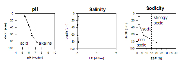
- Increasing alkalinity with depth down the profile.
Key Profile Characteristics
pH | Salinity Rating | |||
Surface (A1 horizon) | strongly acid | very low | non-sodic | none |
Subsoil (B1 horizon) | slightly acid | very low | sodic | none |
Deeper subsoil (at 85 cm) | slightly alkaline | very low | strongly sodic | strong |
 |
Horizon | Horizon Depth | pH (water) | pH CaCl2 | EC 1:5 | NaCl | Exchangeable Cations | |||
Ca | Mg | K | Na | ||||||
meq/100g | |||||||||
A1 | 0-15 | 5.4 | 4.1 | 0.05 | 3.4 | 2 | 0.4 | 0.1 | |
A2 | 15-50 | 6 | 4.6 | <0.05 | 2.6 | 2 | 0.2 | 0.1 | |
B1 | 50-75 | 6.5 | 5.1 | <0.05 | 2.2 | 3.2 | 0.1 | 0.4 | |
B21 | 75-90 | 7.3 | 5.9 | 0.06 | 5.9 | 6.7 | 0.4 | 3.1 | |
B31 | 90-110 | ||||||||
B32 | 110+ | ||||||||
Horizon | Horizon Depth | Ex Al mg/kg | Ex Ac meq/100g | Field pF2.5 | Wilting Point pF4.2 | Coarse Sand (0.2-2.0mm) | Fine Sand (0.02-0.2mm) | Silt (0.002-0.02mm) | Clay (<0.002mm) |
A1 | 0-15 | 107 | 29.8 | 15.7 | |||||
A2 | 15-50 | 26.9 | 13.6 | 7 | 35 | 30 | 27 | ||
B1 | 50-75 | 25.5 | 14.8 | 6 | 31 | 30 | 36 | ||
B21 | 75-90 | 4 | 20 | 17 | 63 | ||||
B31 | 90-110 | ||||||||
B32 | 110+ |
Surface (A) Horizons
- The A horizons have a low overall nutrient status and are moderately to strongly acid. Organic carbon and total nitrogen levels are reasonable (but lowest for all the pits examined).
- The surface horizon has a high (>60%) silt and fine sand content. When cultivated dry, the soil will become "powdery" and the structure will break down. Subsequent heavy rain may promote surface sealing. Tillage should be minimised and stubble retention/pasture rotation practised to build up organic matter levels.
- Aluminium and manganese toxicity may occur in the A1 horizon. This is indicated by the relatively high values for exchangeable aluminium and manganese at this site compared to other sites examined. These levels of exchangeable aluminium may affect sensitive species such as barley, lucerne, medics, canola, phalaris and some wheat varieties. Raising the pH level of the surface soil will help to reduce this toxicity. The pH can be raised by the addition of lime. A lime test (sampled at the paddock level) may be appropriate to determine the amount of lime required.
- The depth of the A horizons is highly variable across the paddock. Within the space of two metres, the depth to the B horizon ranges from 20 to 80 cm. A variation in crop response is likely to occur as a result of this. It is likely that this country originally displayed gilgai microrelief (“crabholey”) that has since been levelled out.
- The conspicuously bleached A2 horizon indicates that periodic waterlogging is likely to occur, resulting in a "soupy" soil.
Subsoil (B) Horizons
- The sodic subsoil (which also has a low calcium:manganese ratio) is likely to restrict root and water movement (as is evident by the bleached A2 horizon).
Notes
- Profile described by John Martin and Mark Imhof (21/4/94)
© State of Victoria (Agriculture Victoria) 1996 - 2025.

This work, Victorian Resources Online, is licensed under a Creative Commons Attribution 4.0 licence. You are free to re-use the work under that licence, on the condition that you credit the State of Victoria (Agriculture Victoria) as author, indicate if changes were made and comply with the other licence terms.
The licence does not apply to ‘branding’ or some ‘images or photographs’ that may be owned by third parties. We ask you to seek prior approval to use images using the VRO feedback form. Access to higher quality images can also be provided on request.
This page was last updated on 24/06/2020.