
LP106
Australian Soil Classification: Magnesic Mesonatric Brown SODOSOL (moderately gravelly surface)
Northocte Factual Key: Db 1.23
Great Soil Group: No suitable group
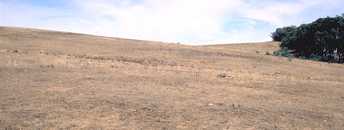
Site Description: Footslope of sedimentary hill.
Geology: Sandstone/siltstone (Ordovician).
Soil Profile Morphology
Surface Soil
| A1 | 0-5 cm | Dark brown (7.5YR3/4); sandy loam; weak medium blocky structure; very firm consistence dry; many fine siltstone gravels; pH 5.8; abrupt and wavy change to: | 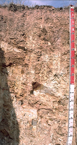 LP106 Profile |
| A2 | 5-20 cm | Reddish brown (2.5YR5/4), conspicuously bleached pink (10YR7/3); sandy loam;massive structure; strong consistence dry; many fine siltstone gravels ; pH 6.8; abrupt and wavy change to: | |
| Subsoil | |||
| B2 | 20-30 cm | Dark yellowish brown (10YR3/6); sandy clay; massive; strong consistence dry; abundant medium sized siltstone gravels ; pH 8.6; gradual and wavy change to: | |
| B/C | 30-60 cm | Strong brown (7.5YR5/6); medium heavy clay; 70% weathering siltstone; strong very fine blocky structure; very strong consistence dry; pH 9.7; diffuse change to: | |
| C | 60+ cm | Weathering siltstone. | |
Key Profile Features
- Strong texture contrast between surface (A) and the top subsoil (B21) horizon.
- High content of alluvial gravel in the surface horizons.
- 70% rock (siltstone) at 30 cm becoming 100% at 60 cm
Key Profile Characteristics
pH | Salinity Rating | |||
Surface (A1 horizon) | Moderately Acidic | Medium | Strongly Sodic | Moderately Dispersive1 |
Subsoil (B21 horizon) | Strongly Alkaline | Low | Strongly Sodic | Strongly Dispersive |
Deeper subsoil (60 cm) | Extremely Alkaline | Low | Strongly Sodic | Strongly Dispersive |
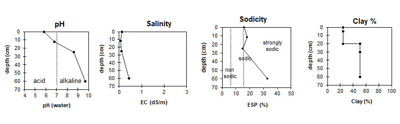
| The surface is moderately acid. The subsoil is alkaline. | The salinity rating in the surface is medium, and low in the subsoil.
| This profile is strongly sodic. | Low clay content in the surface, with a sharp increase at the A/B interface. |
Horizon | Horizon Depth (cm) | pH (water) | pH (CaCl2) | EC dS/m | Organic Carbon % | Exchangeable Cations | Coarse Sand (0.2-2.0 mm) % | Fine Sand (0.02-0.2 mm) % | Silt (0.002-0.02 mm) % | Clay (<0.002 mm) % | Wilting Point % w/w | |||
Ca | Mg | K | Na | |||||||||||
meq/100g | ||||||||||||||
A1 | 0-5 | 5.8 | 4.7 | 0.13 | 4.8 | 2.7 | 3.8 | 0.52 | 1.3 | 18 | 33 | 22 | 24 | 11.4 |
A2 | 5-20 | 6.8 | 5.0 | 0.05 | 1.1 | 3.4 | 0.19 | 0.97 | ||||||
B21 | 20-30 | 8.6 | 7.1 | 0.10 | 1.4 | 9.3 | 0.39 | 1.9 | 6 | 18 | 51 | 51 | 16.2 | |
B22 | 30-60 | 9.7 | 7.9 | 0.44 | 0.58 | 12 | 0.59 | 6.3 | ||||||
| Management Considerations: Whole Profile
Surface (A) Horizons
Subsoil (B) Horizons
Profile Described By: Mark Imhof, Paul Rampant and Karen DePlater, November 1995 |
© State of Victoria (Agriculture Victoria) 1996 - 2025.

This work, Victorian Resources Online, is licensed under a Creative Commons Attribution 4.0 licence. You are free to re-use the work under that licence, on the condition that you credit the State of Victoria (Agriculture Victoria) as author, indicate if changes were made and comply with the other licence terms.
The licence does not apply to ‘branding’ or some ‘images or photographs’ that may be owned by third parties. We ask you to seek prior approval to use images using the VRO feedback form. Access to higher quality images can also be provided on request.
This page was last updated on 03/09/2021.