
LP103
Australian Soil Classification: Vertic (and Hypocalcic), Subnatric, Brown SODOSOL
Northocte Factual Key: Dy 3.43
Great Soil Group: Red-Brown Earth
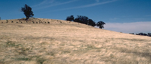
Site Description: Lower slope of a gently undulating rise (2% slope). Original vegetation included Grey Box (Eucalyptus microcarpa).
Geology: Ordovician Sediments (Sandstone)
Soil Profile Morphology
Surface Soil
| A1 | 0-10 cm | Dark brown (7.5YR4/4); sandy loam;massive structure; weak consistence dry; few fine quartz gravels; pH 5.1; abrupt change to: | 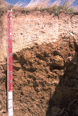 |
| A21 | 10-40 cm | Light yellowish brown (10YR6/4), conspicuously bleached (10YR8/3d); coarse light sandy clay loam; massive; weak consistence dry; many fine quartz gravel; pH 6.4; abrupt and wavy change to: | |
| A22 | 40- 50 cm | Yellow (10YR7/6), conspicuously bleached; sandy clay loam; massive; very firm consistence dry; common medium quartz gravel; pH 7.5; gradual change to: | |
| Subsoil | |||
| B21 | 50-70 cm | Yellowish brown (10YR5/8); medium heavy clay; moderate coarse prismatic structure; strong consistence dry; few fine quartz gravels; slickensides start at 60 cm; pH 7.6; gradual change to: | |
| B22 | 70-130 cm | Dark yellowish brown (10YR4/4), becoming light olive brown (2.5Y5/4) with depth; medium heavy clay; moderate coarse blocky structure; very strong consistence dry; very few manganese stains; pH 9.0. | |
Key Profile Features
- Strong texture contrast between surface (A) and the top subsoil (B21) horizon.
- Conspicuously bleached subsurface (A2) horizon
- Moderate amount (45%) of quartz gravel in the subsurface horizon
Key Profile Characteristics
pH | Salinity Rating | ||
Surface (A1 horizon) | Strongly Acid | Very Low | Non-Sodic |
Subsoil (B21 horizon) | Slightly Alkaline | Very Low | Sodic |
Deeper subsoil ( 85 cm) | Strongly Alkaline | Very Low | Sodic |
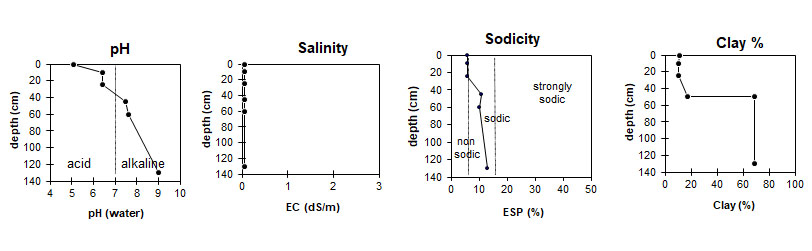
| The surface is strongly acid, slightly alkaline at the upper subsoil, then strongly alkaline at depth. | The salinity rating is very low.
| This profile is sodic. | Low clay content in the surface, with a sharp increase at the A/B interface. |
Horizon | Horizon Depth (cm) | pH (water) | pH (CaCl2) | EC dS/m | Exch. Al ppm | Organic Carbon % | Exchangeable Cations | Coarse Sand (0.2-2.0 mm) % | Fine Sand (0.02-0.2 mm) % | Silt (0.002-0.02 mm) % | Clay (<0.002 mm) % | Wilting Point % w/w | |||
Ca | Mg | K | Na | ||||||||||||
meq/100g | |||||||||||||||
A1 | 0-10 | 5.1 | 4.4 | 0.09 | 26 | 3.5 | 2.4 | 1.1 | 0.18 | 0.20 | 22 | 38 | 29 | 11 | 5.9 |
A21 | 10-40 | 6.4 | 5.3 | <0.05 | 1.2 | 0.67 | <0.05 | 0.11 | 18 | 44 | 33 | 10 | 3.0 | ||
A22 | 40-50 | 7.5 | 6.3 | 0.05 | 0.95 | 2.2 | 0.06 | 0.39 | 19 | 39 | 32 | 17 | 5.0 | ||
B21 | 50-70 | 7.6 | 6.6 | 0.18 | 4.7 | 14 | 0.28 | 1.9 | 9 | 12 | 15 | 69 | 21.5 | ||
B22 | 70-130 | 9.0 | 8.1 | 0.30 | 3.9 | 26 | 0.25 | 4.4 | |||||||
| Management Considerations: Whole Profile The whole profile is sodic but is not dispersive. Some restriction to water and root movement in the deeper subsoil would be expected.
Subsoil (B) Horizons
Comments
Profile Described By: Mark Imhof, Paul Rampant and Karen DePlater, November 1995 |
© State of Victoria (Agriculture Victoria) 1996 - 2025.

This work, Victorian Resources Online, is licensed under a Creative Commons Attribution 4.0 licence. You are free to re-use the work under that licence, on the condition that you credit the State of Victoria (Agriculture Victoria) as author, indicate if changes were made and comply with the other licence terms.
The licence does not apply to ‘branding’ or some ‘images or photographs’ that may be owned by third parties. We ask you to seek prior approval to use images using the VRO feedback form. Access to higher quality images can also be provided on request.
This page was last updated on 03/09/2021.