
Soils and Land Use in the Mid-Loddon Valley, Victoria
This report on the Soils and Land Use in the Mid-Loddon Valley, Victoria was prepared by J.K.M Skene of the former Department of Agriculture in 1971. This report concerns the detailed soil survey of about 620,500 acres of farm land and forest reserve in the Counties of Bendigo, Gladstone, Gunbower and Tatchera. About 359,000 acres is in the constituted Irrigation Areas of Boort, Calivil, Dingee and Tragowel Plains, and of this area approximately 171,700 acres is irrigated. Rather more than half of the irrigated land is under annual pastures, while about one-sixth is under perennial pastures. Other crops irrigated are lucerne, summer fodder crops and cereals. A considerable area of fallow is irrigated prior to sowing cereals. The agricultural pursuits on the irrigated land are fat lamb raising, sheep for wool production and dairying.
To view the information PDF requires the use of a PDF reader. This can be installed for free from the Adobe website (external link).
 | Front page, TOC, acknowledgement (PDF 245KB) | |
| Suitability of the Soils for Various Irrigation Crops (PDF 866KB) | ||
| Soil Features and Irrigation (PDF 722KB) | ||
| Description of Soil Types and Miscellaneous Units (PDF 737KB) | ||
| Landscape Units and Guide to Soil Types (PDF 560KB) | ||
| Soil Associations (PDF 442KB) | ||
| Chemical and Physical Properties (PDF 397KB) | ||
| Classification (PDF 228KB) | ||
| General Information about the Area (PDF 250KB) | ||
| References (PDF 106KB) | ||
| Appendix I - Analytical Data for Representative Profiles (PDF 1.5MB) | ||
| Appendix II - Analytical Methods (PDF 86KB) | ||
| Appendix III - Explanation of Soil Terms (PDF 87KB) | ||
| Appendix IV - Soil Survey Methods (PDF 62KB) | ||
| Appendix V - Factors for Coverting Imperial to Metric Units (PDF 61KB) |
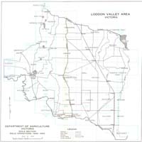 Index to maps - Loddon Valley Area | 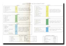 Legend to maps (PDF 285KB) |
© State of Victoria (Agriculture Victoria) 1996 - 2025.

This work, Victorian Resources Online, is licensed under a Creative Commons Attribution 4.0 licence. You are free to re-use the work under that licence, on the condition that you credit the State of Victoria (Agriculture Victoria) as author, indicate if changes were made and comply with the other licence terms.
The licence does not apply to ‘branding’ or some ‘images or photographs’ that may be owned by third parties. We ask you to seek prior approval to use images using the VRO feedback form. Access to higher quality images can also be provided on request.
This page was last updated on 23/03/2020.