
Declared Water Supply Catchments
See also Declared Water Supply Catchments in Victoria
Formally known as Proclaimed Water Supply Catchments, Declared Water Supply Catchment's are the basis for catchment planning and management under the provisions of the Catchment and Land Protection Act, 1994. (formerly the Soil Conservation and Land Utilization Act, 1958).
Under this Act, Declared Special Areas (Water Supply Catchments) officially recognise designated catchments for water supply purposes. This process highlights to the community, land managers and planners, the importance of the catchment for water supply purposes.
Declaration is now initiated by the Catchment Management Authority's (CMA) recommendation to the relevant State Government Minister. Following Ministerial approval, notification is made in the Government Gazette. The Land Conservation Council (LCC) previously had jurisdiction over these proclamations. For some of these DWSCs in the region, the LCC was charged with approving any proposed Determination of Land Use (now known as a Special Area Plan) put forward by the Soil Conservation Authority (SCA). The Determination of Land Use generally established permissible land and water uses within the defined area and stipulated planning controls and potential hazards to the proclaimed water supply.
| The Declared Water Supply Catchments map shows those catchment areas as proclaimed under the Soil Conservation and Land Utilization Act, 1958 in conjunction with the Land Conservation Act, 1970, and subsequently incorporated into the Catchment and Land Protection Act, 1994. This layer identifies domestic Water Supply Catchments that are subject to a Land Use Determination or a Land Use Notice. Data was derived from the proclaimed water supply catchment (L100) layer in the Department of Primary Industries Corporate Geospatial Data Library. Mapping was undertaken by the Centre for Land Protection Research. | 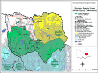 Declared Water Supply Catchments North East Region |
The whole of the Upper Murray River Basin is a Special Water Supply Catchment (SWSC) and a Special Area Plan, previously known as a Land Use Determination (LUD), applies to its northern section (a total area of 6,810 km²). Included within this Basin is the Hume catchment, which was gazetted in 1950 and comprises a total area of 10,062 km². The Northern Section was gazetted in 1984 and comprises a total area of 6,810 km².
Current regulations controlling land use in the Kiewa River Basin include two SWSCs and one Special Area Plan. The first SWSC is the Upper Kiewa catchment, gazetted in 1965 and covering an area of 409 km². The second is Nine Mile, Clear and Hurdle Creeks, gazetted in 1979 and covering an area of just 63 km². The LUD is for the East Kiewa, gazetted in 1984 with a total area of 18 km².
Within the Ovens River Basin, nine SWSCs exist for the purpose of protecting the water supply. They are summarised below:
Special Water Supply Catchment (SWSC) | Year of Gazettal | Area (km2) |
Ovens River (Wangaratta) | 1992 | 298 |
Bakers Gully (Bright) | 1979 | 7 |
King River (Lake William Hovel) | 1979 | 332 |
Buckland River (Porepunkah) | 1979 | 322 |
Fifteen Mile Creek | 1984 | 8 |
Diddah Diddah Creek (Springhurst) | 1984 | 11 |
Ovens River (Bright) | 1984 | 350 |
Buffalo River (Lake Buffalo) | 1984 | 1,150 |
Barambogie Creek (Chiltern) | 1989 | 10.5 |
DWSCs located throughout the North Central region include:
| PWSC No. | Catchment Name |  Part of the Lake Hume catchment |
1 | Lake Hume | |
1a | Lake Hume Northern Section | |
25 | Upper Kiewa | |
25a | Upper Kiewa (East Kiewa) | |
55 | Nine Mile Creek (Beechworth & Yackandandah) | |
55 | Nine Mile Creek, Clear Creek & Hurdle Creek (Lake Kerferd) - Beechworth & Yackandandah | |
56 | Bakers Gully (Bright) | |
58 | King River (Lake William Hovell) | |
59 | Buckland River | |
81 | Fifteen Mile Creek (Glenrowan) | |
82 | Diddah Diddah Creek (Springhurst) | |
83 | Ovens River (Bright) | |
86 | Buffalo River (Lake Buffalo) | |
98 | Ovens River (Wangaratta) | |
116 | Barambogie Creek (Chiltern) |
References
Department of Water Resources (1989). A Water Resource Handbook. Melbourne.
Rothols, W.R., Rowe, R.K., and Terry, K.B. (1965). A Report on the Nature, Aims and Implementation of a Land Use Determination in the Upper Kiewa Water Supply Catchment. Soil Conservation Authority, Kew.
© State of Victoria (Agriculture Victoria) 1996 - 2025.

This work, Victorian Resources Online, is licensed under a Creative Commons Attribution 4.0 licence. You are free to re-use the work under that licence, on the condition that you credit the State of Victoria (Agriculture Victoria) as author, indicate if changes were made and comply with the other licence terms.
The licence does not apply to ‘branding’ or some ‘images or photographs’ that may be owned by third parties. We ask you to seek prior approval to use images using the VRO feedback form. Access to higher quality images can also be provided on request.
This page was last updated on 25/01/2019.