
Public Land
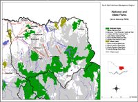 North East National State Parks | This map shows the location of State and National Parks in the North East region, and in nearby regions (as at January 2004). Parks Victoria manages Victoria's world class network of national, state, regional and metropolitan parks, other conservation reserves, many significant cultural assets, and Melbourne's bays and major waterways. The Parks Victoria Parkweb (external link) website provides information about each of Victoria's National and State Parks. |
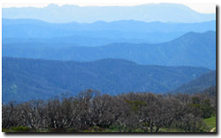 Looking towards Mount Buffalo from Mount Hotham | Public land in the North East region covers about 1.2 million hectares (roughly 54% of the region) and includes the Bogong National Park, which houses the highest mountain peak in Victoria - Mt. Feathertop at 1 922 m asl. Other National Parks in the region include the Cobberas-Tingaringy NP, Burrows-Pine Mountain NP and Mt. Buffalo NP. These National Parks combine with State Parks and Flora & Fauna Reserves to comprise approximately 392 000 hectares (or 17% of the total region). Meanwhile, State Forests occupy 718 700 hectares (more than half the public land and 31% of the total catchment area). The Parks, Flora and Fauna (PFF) Division of DSE is responsible for overseeing the management of Victoria's land and resources for their environmental, conservation and recreational values. PFF is responsible for supporting the conservation of historic places on public land and overseeing the management and use of Crown land. |
Crown Land Management (within the Land Victoria Division of DSE) has a number of roles and responsibilities with respect to the management of public land within the North East region, including:
- Acts on behalf of the Victorian Government as the agent for the Crown land outside of the parks and forests systems, the majority occupied by individuals and organisations/clubs other than the Department of Sustainability and Environment;
- Purchases, exchanges, sells, reserves and leases or licences land and property for DSE and other parts of Government;
- Provides policy and a regulatory framework for the reservation, management and use of Crown land;
- Facilitates major Government and private infrastructure projects through the commercial leasing, reservation and delegated management of Crown land;
- Maintains the Crown land data base covering relevant Crown allotments;
- For the purposes of Native Title claims, researches and determines the tenure history of Crown land under claim and provides DSE policy input to the Government’s response to Native Title;
- Coordinates responses to land use planning proposals on behalf of DSE;
- Acts as a referral authority for proposed developments on private and Crown land;
- Provides new information technology developments and initiatives to support cadastral and natural resource decision-making and program delivery.
© State of Victoria (Agriculture Victoria) 1996 - .

This work, Victorian Resources Online, is licensed under a Creative Commons Attribution 4.0 licence. You are free to re-use the work under that licence, on the condition that you credit the State of Victoria (Agriculture Victoria) as author, indicate if changes were made and comply with the other licence terms.
The licence does not apply to ‘branding’ or some ‘images or photographs’ that may be owned by third parties. We ask you to seek prior approval to use images using the VRO feedback form. Access to higher quality images can also be provided on request.
This page was last updated on .