CFTT03
| Location: Tostaree | |
| Australian Soil Classification: Bleached-Mottled, Magnesic, Brown CHROMOSOL | |
| Great Soil Group: soloth | Tech. Class: 052-6-50/2-1-3-32 |
| General Landscape Description: Undulating plain | Site Description: 3 % slope to east |
| Geology: Tertiary sediments | |
Soil Profile Morphology:
Surface Soil
| A1 | 0-15 cm | Very dark greyish brown (10YR3/2); loamy fine sand; weak granular structure (less than 5 mm); very weak consistence moist; pH 5.3; clear and wavy transition to: |  Site CFTTO3 Profile Site CFTTO3 Profile |
| A2 | 15-55 cm | Light yellowish brown (10YR6/4), conspicuously bleached (10YR7/3, dry), loamy fine sand; massive; very weak consistence dry; pH 5.4; sharp and wavy transition to: | |
| Subsoil | |||
| B21 | 55-100 cm | Dark yellowish brown (10YR4/6), with common, coarse, distinct yellowish red (5YR4/6) mottles; light medium clay; moderate coarse subangular blocky structure, parting to moderate medium polyhedral structure; very firm consistence moist; pH 5.5; diffuse and smooth transition to: | |
| B22 | 100-140 cm | Red (2.5YR4/6), with many, coarse, prominent dark yellowish brown (10YR4/6) and light brownish grey (10YR6/2) mottles; light medium clay; strong medium prismatic structure, parting to strong medium polyhedral structure; strong consistence moist; mottling becomes more pronounced with depth; pH 5.5. | |
Key Profile Features:
- Very strong texture contrast between sandy surface (A) horizons and clay subsoil (B21) horizon.
- Conspicuously bleached subsurface (A2) horizon
Soil Profile Characteristics:
Horizon | pH | Salinity Rating | ||
Surface (A1 horizon) | Strongly Acid | Very Low | - | - |
Subsoil (B21 horizon) | Strongly Acid | Very Low | Non-Sodic | - |
Deeper subsoil (at 1 m) | Strongly Acid | Very Low | Non-Sodic | - |
 |  |  |  |
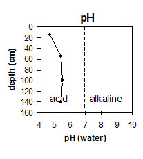
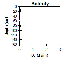
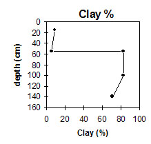
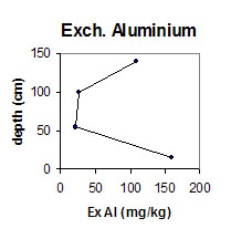
The soil profile is strongly acid throughout. | The level of soluble salts is very low throughout the soil profile. | The level of exchangeable aluminium is high in the strongly acid surface soil, and becomes lower at depth. | The clay content increases significantly at the A/B horizon interface. |
Horizon | Horizon Depth (cm) | pH (water) | pH (CaCl2) | EC 1:5 | Exchangeable Cations | |||
Ca | Mg | K | Na | |||||
meq/100g | ||||||||
A1 | 0-15 | 5.3 | 4.3 | 0.08 | 0.81 | 0.93 | 0.18 | 0.19 |
A2 | 15-55 | 5.4 | 4.6 | <0.05 | 0.33 | 0.19 | 0.08 | 0.06 |
B21 | 55-100 | 5.5 | 4.9 | 0.11 | 1.4 | 11 | 0.13 | 1.1 |
B22 | 100-140 | 5.5 | 4.7 | <0.05 | 0.1 | 0.65 | <0.05 | 0.08 |
Horizon | Horizon Depth (cm) | Exchangeable Aluminium mg/kg | Exchangeable Acidity meq/100g | Field Capacity pF 2.5 | Wilting Point pF 4.2 | Coarse Sand (0.2-2.0 mm) | Fine Sand (0.02-0.2 mm) | Silt (0.002-0.02 mm) | Clay (<0.002 mm) |
A1 | 0-15 | 160 | 16 | 17.9 | 8.4 | 28.2 | 44 | 13 | 9 |
A2 | 15-55 | 22 | 2.3 | 15.5 | 2.3 | 31.8 | 47.6 | 14.5 | 5.5 |
B21 | 55-100 | 27 | 13 | 49.1 | 31 | 3 | 9.3 | 4 | 82.5 |
B22 | 100-140 | 25 | 3 | 14.3 | 3.4 | 1.4 | 19.6 | 6.5 | 70.5 |
Management Considerations:
- The subsoil has a low exchangeable calcium:magnesium ratio. Calcium deficiencies may occur as a result.
- The soil profile is strongly acid throughout. Availability of some trace elements (eg. copper, molybdenum) may be low as a result. Aluminium toxicity can be a problem in strongly acid soils. The levels measured here are only high in the surface (A1) horizon.


