Soil/Landform Unit 29
Landform Unit Description
Page top
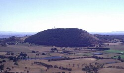 Mount Buninyong (note that the south-easterly slopes have largely been cleared fro hardwood forestry) |
0.04% of CMA region The high cones of Mount Warrenheip and Mount Buninyong form part of sequence of volcanic landforms within the Midlands of the Western Uplands. These cones are characterised by cone crests and slopes, lower undulating slopes, depressions and alluvial terraces. The cones support the vegetation class Herb-rich Foothill Forest with the dominant species being manna gum (E. viminalis), narrow leaf peppermint (E. radiata) and messmate stringybark (E. obliqua). The crests and slopes provide friable dark red gradational soils, while the depressions host a mixture of sodic texture contrast soils. Agricultural land use is limited by the steep nature of the cone and surrounding slopes. Both cones have high environmental and scenic value while actively being used by the community for passive and active forms of recreation (e.g. cross country running). Hardwood forestry and residential development are the most popular land uses at present along with water supply. Erosion hazards are minimal. Areas with shallow stony gradational soils are susceptible to leaching of nutrients, and compaction is a problem on the lower slopes and depressions. Minor gully erosion and waterlogging is associated with the lower slopes and the texture contrast soils of the depressions. | 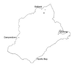 |
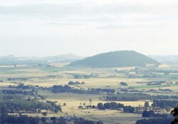 Mount Warrenheip | 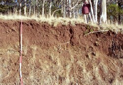 Regolith profile of the scoria cone Mount Warrenheip |
| 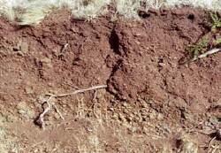 Dark red gradational profile of Mount Warrenheip |
| 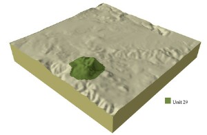 |
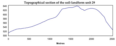 |
Component | 1 | 2 | 3 | 4 |
Proportion of soil-landform unit | 9% | 8% | 8% | 75% |
| CLIMATE Rainfall (mm) | Annual: 880 | |||
| Temperature (oC) | Minimum 6, Maximum 17 | |||
| Precipitation less than potential evapotranspiration | November-March | |||
| GEOLOGY Age and lithology | Pleistocene basalt, scoria tuff | |||
| Geomorphology | ||||
| LANDUSE | Uncleared: Nature conservation; passive and active recreation; water supply; hardwood forestry | |||
| TOPOGRAPHY Landscape | Moderately inclined low cones | |||
| Elevation range (m) | 505-740 | |||
| Local relief (m) | 120 | |||
| Drainage pattern | Dendritic | |||
| Drainage density (km/km2) | 0.5 | |||
| Landform | Undulating plains | Volcanic cone | ||
| Landform element | Crest and upper slopes | Mid slope | Lower slopes and depressions | Slopes and crest |
| Slope and range (%) | 4 (1-6) | 3 (2-7) | 1 (1-2) | 25 (5-40) |
| Slope shape | Convex | Straight | Concave | Straight |
| NATIVE VEGETATION Ecological Vegetation Class | Herb-rich Foothill Forest (34.1%) | |||
| Dominant species | E. viminalis, E. radiata, E. obliqua | E. viminalis, E. radiata, E. obliqua | E. viminalis, E. radiata, E. obliqua | E. viminalis, E. radiata |
| SOIL Parent material | In situ weathered basalt and scoria | In situ weathered basalt and scoria | In situ weathered basalt and scoria | In situ weathered basalt and scoria |
| Description (Corangamite Soil Group) | Red gradational soil, fine structure (40) | Dark red gradational soil, fine structure (40) | In situ weathered basalt and scoria. Stony red gradationl soil (40) | |
| Soil type sites | ||||
| Surface texture | Clay loam | Loam | Clay loam | Clay loam |
| Permeability | High | High | Moderate to low | High |
| Depth (m) | 2 | 1.5 | 1.5 | 1 |
| LAND CHARACTERISTICS, POTENTIAL AND LIMITATIONS | Overland flow, sheet erosion and nutrient decline are very minor. These soils have a high aricultural versatility but are limited where surface stones occur. | Overland flow, sheet erosion and nutrient decline are very minor. These soils have a high agricultural versatility but are limited where surface stones occur. | Low permability and hardsetting surfaces lead to waterlogging and soil compaction | Steep slopes, overland flow, sheet erosion and nutrient decline are very minor. These soils have a high agricultural versatility. |

