Soil/Landform Unit 122
Landform Unit Description
Page top
 The gently undulating plains include the township of Cobden (looking at the western end of Cobden towards Ewen Hill) |
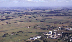
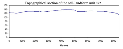
0.38% of CMA region Basaltic plains running from Cobden to Glenfyne are characterised by long gentle slopes with stringybarks (E. obliqua and E. baxteri) and swamp gums (E. ovata). The gently undulating plains of the Western Plains are bounded by a steep scarp to the east defining the margin with the entrenched valley of the Curdies River. This dissection has produced magnificent dissected terrain highlighting a wide diversity of geologies and vegetation types. Owing to the mix of geologies on the plains (Quaternary basalt and Neogene fluvio-marine sand), there is a wide range of soils. The major soils are sporadically bleached, mottled texture contrast soils with some upper slopes and crests having a few surface stones that are easily cleared. Upper slopes and crests are known to have shallow friable gradational soils associated with these stones. There are minor occurrences of texture contrast soils on the slopes, with relatively poorly drained equivalents on the flats. Grey cracking clays are found in depressions and drainage lines. Gilgai patches occur on these plains with the texture contrast soils common on both mounds and depressions. Buckshot in surface horizons is higher in depressions compared to mounds. Land use is quite diverse and includes dairy farming, beef cattle and sheep grazing, water supply, softwood plantation and residential development (especially around Cobden). Erosion hazards are minimal except at scarps, which have a high susceptibility to mass movement. Areas with shallow stony gradational soils are susceptible to leaching of nutrients, and compaction is a problem on the flatter gilgaied areas. | 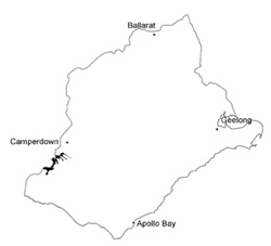 |
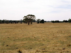 Grassed gently undulating plains are used for grazing (sheep, beef and dairy cattle) | 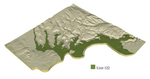 |
 |  Grassed plains, most large vegetation has been removed and replaced with annual/perennial pastures |
Component | 1 | 2 | 3 | 4 | 5 |
Proportion of soil-landform unit | 14% | 6% | 45% | 30% | 5% |
| CLIMATE Rainfall (mm) | Annual: 860 | ||||
| Temperature (oC) | Minimum 9, Maximum 18 | ||||
| Precipitation less than potential evapotranspiration | November-March | ||||
| GEOLOGY Age and lithology | Quaternary basalt, Neogene fluvio-marine sand | ||||
| Geomorphology | |||||
| LANDUSE | Uncleared: Nature conservation; water supply Cleared: Dairy farming; beef cattle and sheep grazing; water supply; softwood plantation | ||||
| TOPOGRAPHY Landscape | Gently undulating basalt plains | ||||
| Elevation range (m) | 61-149 | ||||
| Local relief (m) | 2-5 | ||||
| Drainage pattern | Dendritic | ||||
| Drainage density (km/km2) | 0.8 | ||||
| Landform | Low rises | Plains | Drainage depressions | ||
| Landform element | Broad low crests and upper slopes | Mid slopes | Long gentle lower slopes | Flats | Swamps and depressions |
| Slope and range (%) | 3 (1-5) | 6 (3-10) | 2 (1-5) | 1 (0-3) | 2 (1-5) |
| Slope shape | Convex | Irregular | Concave | Straight | Concave |
| NATIVE VEGETATION Ecological Vegetation Class | Herb-rich Foothill Forest (2.3%), Plains Grassy Woodland (1.4%) | ||||
| SOIL Parent material | Basalt | Basalt | Basalt and colluvium | Basalt | Alluvial sand, silt and clay and basaltic colluvium |
| Description (Corangamite Soil Group) | Acidic and neutral mottled brown, grey or yellow texture contrast soils (37) | Acidic and neutral mottled brown, grey or yellow texture contrast soils (37) | Acidic and neutral mottled brown, grey or yellow texture contrast soils (37) | Acidic mottled black texture contrast soils and grey cracking clays (31) | |
| Soil type sites | |||||
| Surface texture | Fine sandy clay loam | Fine sandy clay loam | Fine sandy clay loam | Clay loam | Fine sandy clay loam, light medium clay |
| Permeability | Low to moderate | Low to moderate | Low | Low | Low to very low |
| Depth (m) | <2 | <2 | >2 | >2 | >2 |
| LAND CHARACTERISTICS, POTENTIAL AND LIMITATIONS | Texture contrast soil, moderate water holding capacity and moderate nutrient holding capacity in surface and subsurface soils, higher in deep subsoil. Low to very low permeability. Stony. Non-sodic subsoil. Moderate site drainage. | Texture contrast soil, moderate water holding capacity and moderate nutrient holding capacity in surface and subsurface soils, higher in deep subsoil. Low to high permeability (friable loams). Some stone. Non-sodic subsoil. Moderately rapid site drainage. | Texture contrast soil, moderate water holding capacity and moderate nutrient holding capacity in surface and subsurface soils, higher in deep subsoil. Low permeability. Some stone. Non-sodic subsoil. Moderate to slow site drainage. Possible compaction. | Texture contrast soil, moderate water holding capacity and moderate nutrient holding capacity in surface and subsurface soils, higher in subsoil. Low permeability. Some stone. Non-sodic subsoil. Moderate to slow site drainage. Possible compaction. | Uniform firm texture and texture contrast, expansive clays, high water holding capacity and nutrient holding capacity. Strongly sodic subsoil, possible surface soil associated with poor drainage. Some friable self-mulching surfaces with high organic matter. Very slow site drainage. |


