
7.4 Parallel Ridge and Valley (Pliocene Ridges)
|
This information has been developed from the publications:
|
| Location: | 7-995327. Nine kilometres south east of Simpson. | |
Access: | Crescent Road. | |
Ownership: | Mostly private land and some Crown land (Road Reserve). | |
Geology/Geomorphology: | This site is a clear example of parallel drainage aligned north- north-west. This pattern is typical of the north-west of the shire and is also represented (and discussed) on Sites 6.1 and 7.2. There are extensive old landslip scars on the valley sides and a site of possible stream capture is indicated. | |
Significance: | State. The difference between this site and Site 6.1 is in the material comprising the ridges which here is not Moorabool Viaduct Formation sands. The drainage pattern may have been superimposed from overlying deposits (since eroded away) but as at Site 6.1, further work is necessary to explain these features. | |
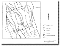 Morphology of Site 7.4 |
© State of Victoria (Agriculture Victoria) 1996 - 2025.

This work, Victorian Resources Online, is licensed under a Creative Commons Attribution 4.0 licence. You are free to re-use the work under that licence, on the condition that you credit the State of Victoria (Agriculture Victoria) as author, indicate if changes were made and comply with the other licence terms.
The licence does not apply to ‘branding’ or some ‘images or photographs’ that may be owned by third parties. We ask you to seek prior approval to use images using the VRO feedback form. Access to higher quality images can also be provided on request.
This page was last updated on 23/03/2020.