
6.1 Simpson - Parallel Drainage
|
This information has been developed from the publications:
|
| Location: | 6-910330. Five kilometres south of Simpson. | |
Access: | Centre Road. | |
Ownership: | Private land. | |
Geology: | Two formations, the Gellibrand Marl and Moorabool Viaduct Formation outcrop in the north west of the Otway Shire. The Moorabool Viaduct Formation is sandy and has been extensively laterized producing duplex soils. It acts as a cap rock overlying the calcareous and softer sediments of the Gellibrand Marl. | |
Geomorphology: | Two landforms are evident in this unit: narrow, flat topped ridges with a distinct break of slope above the valley side, and a marked parallelism of valleys. The origin of this drainage pattern has not been satisfactorily explained. It may be due to structural control e.g. faulting in the underlying rocks. However, Thompson (1971) and Jenkin (1981) suggest streams may be aligned in depressions initiated behind beach ridges stranded by the retreating Miocene sea. This pattern became a permanent land feature as the area was later uplifted and drainage lines became more deeply entrenched. | |
Significance: | State. The ridge and valley pattern is of considerable significance in determining the landscape evolution of Victoria. It is noted that the pattern is also more widely represented in adjacent shires to the west and north. | |
References: | Jenkin, J. J. (1981). Evolution of the Victorian Coastline Proceedings of Royal Society of Victoria, 92(1), 37-54. Thompson, B.R. (1971). The geology and hydrogeology of the Corangamite region. MSc Thesis, University of. Melbourne, unpublished.Bowen, D.Q. 1974 'The Quaternary of Wales.' IN: Owen, T.R. (ed.) The Upper Palaeozoic and Post Palaeozoic Rocks of Wales. University of Wales Press, | |
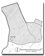
Site 6.1 and 6.2
© State of Victoria (Agriculture Victoria) 1996 - 2025.

This work, Victorian Resources Online, is licensed under a Creative Commons Attribution 4.0 licence. You are free to re-use the work under that licence, on the condition that you credit the State of Victoria (Agriculture Victoria) as author, indicate if changes were made and comply with the other licence terms.
The licence does not apply to ‘branding’ or some ‘images or photographs’ that may be owned by third parties. We ask you to seek prior approval to use images using the VRO feedback form. Access to higher quality images can also be provided on request.
This page was last updated on 23/03/2020.