
7.2 Kennedys Creek - Landslip Terraces
|
This information has been developed from the publications:
|
| Location: | 7-030350. Nine kilometres north east of Carlisle River. | |
Access: | Tomahawk Creek Road. | |
Ownership: | Private land. | |
Geology/Geomorphology: | The site includes the valley of a tributary of Kennedys Creek and part of the adjacent flat topped divides. The western valley wall displays a regular array of basin shaped landslip scars that have cut a distinctive scalloped pattern into the interfluve. The pattern on the eastern valley side is less regular. | |
Significance: | Regional. The site displays a process of valley widening that is important in shaping the topography of the north western part of the Shire. This particular valley has a noticeably higher number of landslip sites than other tributaries of Kennedys Creek. | |
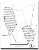 Site 7.2 and 7.3 | 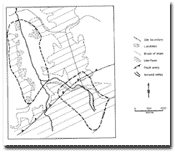 Morphology of Site 7.2 and 7.3 |
© State of Victoria (Agriculture Victoria) 1996 - 2025.

This work, Victorian Resources Online, is licensed under a Creative Commons Attribution 4.0 licence. You are free to re-use the work under that licence, on the condition that you credit the State of Victoria (Agriculture Victoria) as author, indicate if changes were made and comply with the other licence terms.
The licence does not apply to ‘branding’ or some ‘images or photographs’ that may be owned by third parties. We ask you to seek prior approval to use images using the VRO feedback form. Access to higher quality images can also be provided on request.
This page was last updated on 23/03/2020.