
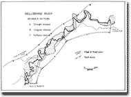
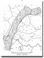
7.9 Gellibrand River Meanders
|
This information has been developed from the publications:
|
| Location: | 7-005238 to 15-970213. A five kilometre section of the Gellibrand River beginning near Mt McKenzie and extending to one kilometre below the confluence of Kennedys Creek. | 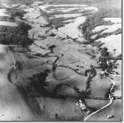 Meanders of the Gellibrand River |
Access: | Gellibrand River Road. | |
Ownership: | Crown land (River Reserve) and private land. | |
Geomorphology: | This site illustrates the changing meander form of the Gellibrand River along a sector of confined flood plain north of Devondale. The contorted or tortuous meander sector is on the wider flood plain near the confluence of Kennedys Creek. Unlike the river sector at Sites 7.7 and 7.10, levee banks are not well developed on the wide flood plain. The river valley is here aligned along a fault trending north-easterly to the west of the valley. | |
Significance: | Regional. The abrupt change in meander patterns illustrates one of the varied characteristics of the longest river in the Otway region. |
© State of Victoria (Agriculture Victoria) 1996 - .

This work, Victorian Resources Online, is licensed under a Creative Commons Attribution 4.0 licence. You are free to re-use the work under that licence, on the condition that you credit the State of Victoria (Agriculture Victoria) as author, indicate if changes were made and comply with the other licence terms.
The licence does not apply to ‘branding’ or some ‘images or photographs’ that may be owned by third parties. We ask you to seek prior approval to use images using the VRO feedback form. Access to higher quality images can also be provided on request.
This page was last updated on .