
7.10 Gellibrand River Valley
|
This information has been developed from the publications:
|
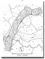
| Location: | 7 - 000239. Gellibrand River valley two kilometres north west-west of Mt. McKenzie. (This site overlaps Site 7.9.) |
| Access: | Off Gellibrand River Road. |
| Ownership: | Private land and some Crown Land. |
| Geomorphology: | This site is distinctive for the high levee banks that occur in a narrow valley sector. |
| The levees indicate a change from a predominantly erosive river regime to an aggradational phase when floodplain sediments including levee banks were deposited. It is probable that levee growth is now very limited as the river is deeply incised into floodplain deposits. | |
| Significance: | Regional. The Gellibrand River has levee banks at several localities and this is one of the best inland examples. |
 7.9 to 7.10 |
© State of Victoria (Agriculture Victoria) 1996 - .

This work, Victorian Resources Online, is licensed under a Creative Commons Attribution 4.0 licence. You are free to re-use the work under that licence, on the condition that you credit the State of Victoria (Agriculture Victoria) as author, indicate if changes were made and comply with the other licence terms.
The licence does not apply to ‘branding’ or some ‘images or photographs’ that may be owned by third parties. We ask you to seek prior approval to use images using the VRO feedback form. Access to higher quality images can also be provided on request.
This page was last updated on .