
7.7 Gellibrand River - Confined Floodplain and Gorge
|
This information has been developed from the publications:
|
| Location: | 7-018260. Eight kilometres south of Carlisle River. | 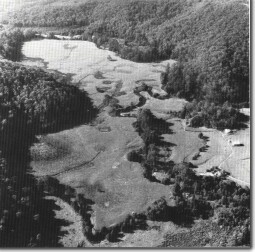 Gellibrand River floodplain. |
Access: | Gellibrand River Road and King Track. | |
Ownership: | Mainly private land and some Crown land (River Reserve). | |
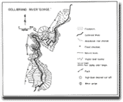
Geology/Geomorphology: | This large site displays the effect of faulting on river alignment and the development of a confined floodplain. The western valley wall is a fault scarp. Depositional features of particular interest are mapped and include levee banks, abandoned channel sectors, and small flood crevasses. Of particular interest is an apparently higher level cutoff which may be an expression of relatively recent movement on the fault. | |
Significance: | State. Faulting is a major structural feature of the Otway Ranges area and this site displays clearly the physiographic effects of recent fault movement. Stages in confined flood plain development and the interplay of tectonics, river erosion and deposition may be studied here in some detail. | |
© State of Victoria (Agriculture Victoria) 1996 - .

This work, Victorian Resources Online, is licensed under a Creative Commons Attribution 4.0 licence. You are free to re-use the work under that licence, on the condition that you credit the State of Victoria (Agriculture Victoria) as author, indicate if changes were made and comply with the other licence terms.
The licence does not apply to ‘branding’ or some ‘images or photographs’ that may be owned by third parties. We ask you to seek prior approval to use images using the VRO feedback form. Access to higher quality images can also be provided on request.
This page was last updated on .