
8.2 Bunker Hill - Fault and Older Volcanic Basalt
|
This information has been developed from the publications:
|
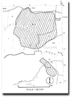
| Location: | 8-155335. Nine kilometres west of Gellibrand. | |
Access: | Bunker Hill Track. | |
Ownership: | Private land and some Crown land. | |
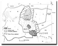
Geology/Geomorphology: | The Gellibrand River follows the alignment of the Loves Creek and Bunker Hill Faults and has eroded a window into the Lower Cretaceous Otway Group sediments. These occur north of the river while on the southern side are sediments of the Eastern View Formation. Included in these are small intrusions and flows of Older Volcanic basalt which are exposed on the northern slopes of Mount Murray and at river level. A massive landslip is conspicuous on the northern valley slope with a deep headwall scarp just below the ridge crest and irregular lobate ridges of slip material at the valley base. | |
Significance: | Regional. Along with other outcrops in the Gellibrand district, these are the only surface volcanic rocks in the Otway region. The Gellibrand River where it crosses the Otway Group has steep valley side slopes and lacks a floodplain and this contrasts with areas downstream where it crosses less resistant Tertiary rocks (Sites 7.7 and 7.9). | |
© State of Victoria (Agriculture Victoria) 1996 - .

This work, Victorian Resources Online, is licensed under a Creative Commons Attribution 4.0 licence. You are free to re-use the work under that licence, on the condition that you credit the State of Victoria (Agriculture Victoria) as author, indicate if changes were made and comply with the other licence terms.
The licence does not apply to ‘branding’ or some ‘images or photographs’ that may be owned by third parties. We ask you to seek prior approval to use images using the VRO feedback form. Access to higher quality images can also be provided on request.
This page was last updated on .