Site LS19
Location: Woorak
Australian Soil Classification: Vertic (and Calcic), Mottled-Mesonatric, Red SODOSOL
Northcote Factual Key: Dy 2.13
Great Soil Group: red-brown earth (sodic)
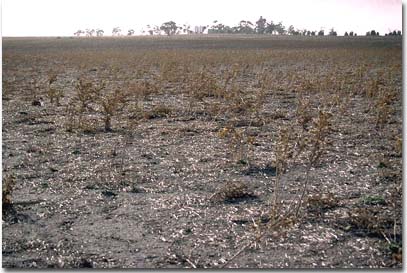
General Landscape Description: Mid slope on the western side of a north-south trending gently undulating rise. Slopes are generally between 1-3%.
 LS19 Landscape |
Soil Profile Morphology:
Surface Soil
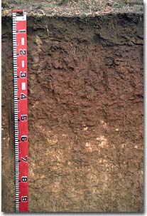
| A1 | 0-15 cm | Dark brown (7.5YR4/2); heavy sandy clay loam; weakly structured; platy fragments occur at the base of this horizon; pH 7.0: |  LS19 Profile |
| Subsoil | |||
| B21 | 15-50 cm | Reddish brown (5YR5/4) with red (2.5YR5/8) mottles; heavy clay; strong medium prismatic, parting to strong coarse blocky structure; very strong consistence dry; pH 8.5: | |
| B22 | 50-80 cm | Yellowish red (5YR5/6); medium heavy clay; moderate prismatic, parting to blocky structure; contains few (5 - 10%) soft calcareous segregations; pH 9.2: | |
| B23 | 80-170 cm | Very pale brown (10YR7/4) with reddish yellow (5YR6/8) striations along prism faces; medium heavy clay; strong medium prismatic, parting to moderate medium blocky structure; firm consistence moist; pH 9.2: | |
| B24 | 170+ cm | Pale yellow (2.5YR7/4); heavy clay; strong coarse lenticular structure; very firm consistence moist; pH 9. | |
Key Profile Features:
- Texture contrast between surface and subsoil horizons.
- Hardsetting surface soil.
- Vertic properties (ie. presence of lenticular structure) in deeper subsoil.
Soil Profile Characteristics:
pH | Salinity | |||
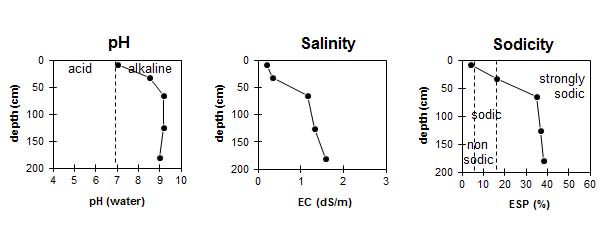
Surface (A1 horizon) | Neutral | Very Low | Non-Sodic | Slaking, No Dispersion |
Subsoil (B21 horizon) | Moderately Alkaline | Low | Strongly Sodic | Strong |
Deeper Subsoil (at 1 metre) | Strongly Alkaline | high | Strongly Sodic | _ |

| The surface soil is neutral. The subsoil is moderately alkaline becoming strongly alkaline at depth. | The salinity rating is very low in the surface and low in the upper subsoil becoming high with depth. | The surface is non-sodic. The subsoil is strongly sodic. |
Management Considerations:
Surface (A) Horizon
- When dry the surface soil will set hard and become difficult to work.
- The surface soil is non-sodic but will slake. Slaking can result in the formation of a surface seal which restricts water intake and increases run off as well as reducing seedling emergence. Organic matter levels at this site are relatively low which may result in increased slaking. Practices such as residue retention, minimum tillage and including pasture rotations should be utilised if cropping occurs in order to build up organic matter levels.
- The surface soil may be prone to compaction when overworked, as is shown by the development of platy-like soil fragments at the base of the surface horizon. Tillage or excessive trafficking should be avoided if the soil is in a moist to wet condition (ie. wetter than the plastic limit).
- The surface soil has a low to moderate inherent fertility (based on the sum of the basic exchangeable cations). Improving organic matter levels will assist in increasing soil fertility as well as water holding capacity.
Subsoil (B) Horizons
- Subsoil from 15 cm and below is strongly sodic and strongly dispersive and therefore likely to restrict root and water movement down the profile. After heavy rains waterlogging could occur above the subsoil.
- The high level of soluble salts in the deeper subsoil (ie. from 50 cm depth) may restrict the growth of salt sensitive species.
Comments from Landholder:
- Gypsum required due to soil becoming 'soupy' when overworked when wet.
- Good cropping soil but not suited to continuous cropping.
- Fallow/wheat/peas/canola rotation has been used.
- Superphosphate and nitrogen has been applied.


