Your gateway to a wide range of natural resources information and associated maps

Victorian Resources Online

Erosion in Victoria (1938)

Photo gallery

The following document regarding the state of erosion in Victoria was published in 1938. Briefly, it contains a discussion of the types of erosion found as well as their causes, effects, reclamation and control. Measures appropriate for erosion control on both state- and privately-owned land were also considered.


To view the information PDF requires the use of a PDF reader. This can be installed for free from the Adobe website (external link).
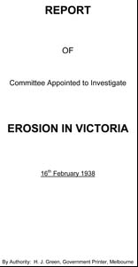


Erosion_in_Victoria


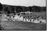
gully_erosion_vic

Gully through grassland at Bindi, Upper Tambo, 25 ft to 30 ft deep (1938)
Part 1 Erosion in Victoria
EROSION_VICTORIA.pdf
(PDF 137KB)
Appendix - Types of Erosion
Sheet Erosion
EROSION_VICTORIA_appendixsheet (1).pdf
(PDF 570KB)

Appendix - Types of Erosion
Gully Erosion
EROSION_VICTORIA_appendixgul (2).pdf
(PDF 559KB)

Appendix - Types of Erosion
Stream Erosion

EROSION_VICTORIA_appendixstream (3).pdf
(PDF 201KB)

Appendix - Types of Erosion
Landslides
EROSION_VICTORIA_appendixland (4).pdf
(PDF 176KB)

Appendix - Types of Erosion
Wind
EROSION_VICTORIA_appendixwind (5) .pdf
(PDF 156KB)

Appendix - Types of Erosion
Siltation
EROSION_VICTORIA_appendixsiltation (6).pdf
(PDF 381KB)
Appendix - Types of Erosion
Methods of Control
EROSION_VICTORIA_appendixcontrol (7).pdf
(PDF 281KB)


Photo gallery
Page top