PPW8
Location: Werribee - Research Farm
Aust. Soil Class.: Vertic (& Sodic), Calcic, Brown DERMOSOL / Vertic, Mottled-Mesonatric, Grey SODOSOL
Northcote Factual Key:: Ug 5.25
Great Soil Group:: solodic
Previous Soil Type (Skene 1954): Austral clay loam (depressions at junction of basalt and alluvial deposits)
Maher and Martin (1979) map unit: 8/7
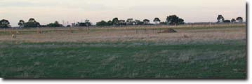
General Landscape Description: Level plain.
Site Description: Grazing paddock.
Geology: Quaternary alluvial (prior stream) and aeolian deposits/Quaternary basalt.
 WP5 Landscape |
Soil Profile Morphology
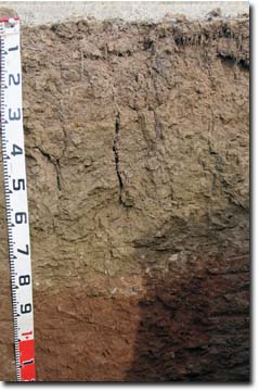
Surface Soil |  PPW8 Profile | ||
A1 | 0-5 cm | Dark brown (10YR3/3); heavy clay loam (fine sandy); hardsetting surface condition; very firm consistence (dry); many roots present; pH 5.2; clear change to: | |
Subsoil | |||
B21 | 5-30 cm | Dark yellowish brown (10YR4/4) with yellowish brown (10YR5/6) mottles; medium clay; strong coarse-medium blocky structure; strong consistence (dry); pH 5.9: | |
B22 | 30-60 cm | Light olive brown (2.5Y5/4 and 5/6); medium heavy clay; strong coarse blocky structure; strong cracking when dry; very strong consistence (dry); pH 7.7: | |
B23 | 60-80 cm | Light yellowish brown (2.5Y6/4); medium heavy clay; very strong consistence (slightly moist); few (5%) medium calcareous nodules (2-5 mm); few roots; pH 8.9: | |
B24 | 80-120 cm | Yellowish red (5YR5/6 & 5/8); medium clay; very strong consistence (slightly moist); few (5%) fine calcareous nodules and few (2 %) basalt fragments (2-5 cm); pH 8.8: | |
| B25k | 120-140 cm | Yellowish red (5YR5/6); medium clay; many (20 %) fine calcareous nodules and very few (2 %) basalt fragments; pH 8.9. | |
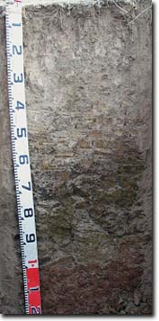
 | Note: In some areas, a discontinuous bleached subsurface horizon of variable depth (up to 50 cm) is present. This horizon is yellowish brown; conspicuously bleached (10YR 7/3 dry); very fine sandy clay loam with some rusty root channel mottling. This bleached horizon overlies a greyish brown (2.5Y 5/2) with light olive brown (2.5Y5/6) mottles heavy clay subsoil (B21) horizon. At depth, the subsoil becomes light olive brown (2.5Y 5/4), before becoming yellowish red (5YR 5/6) at 90 cm depth. This soil profile variation is related to the original gilgai microrelief. |
Key Profile Features
- Soil profile variation related to gilgai microrelief (e.g. variable presence of bleached subsurface horizon, depth to subsoil clay horizons).
pH | Salinity Rating | |||
Surface (A1 horizon) | Strongly Acid | Low | Non-Sodic | None |
Subsoil (B21 horizon) | Moderately Acid | Low | Sodic | None1 |
Deeper subsoil (at 120-140 cm) | Strongly Alkaline | Very High | Strongly Sodic | None2 |
| 1Moderate to strong dispersion after remoulding. 2Slight dispersion after remoulding. Lack of dispersion likely due to high level of soluble salts deeper in the soil profile. | ||||
 |
Horizon | Horizon Depth (cm) | pH (water) | pH CaCl2 | EC dS/m | NaCl % | Exchangeable Cations | Boron (CaCl2) mg/kg | Ex Al mg/kg | Ex Ac meq/100g | Field pF2.5 | Wilting Point pF4.2 | Coarse Sand (0.2-2.0mm) | Fine Sand (0.02-0.2mm) | Silt (0.002-0.02mm) | Clay (<0.002mm) | |||
Ca | Mg | K | Na | |||||||||||||||
meq/100g | ||||||||||||||||||
A1 | 0-5 | 5.2 | 4.8 | 0.38 | 0.03 | 7.0 | 3.4 | 2.5 | 0.3 | <10 | 15 | 38.2 | 16.7 | 12 | 25 | 19 | 31 | |
B21 | 5-30 | 5.9 | 5.3 | 0.17 | 6.4 | 6.8 | 0.82 | 1.1 | <10 | 11 | 29.8 | 16.9 | 3 | 31 | 20 | 43 | ||
B22 | 30-60 | 7.7 | 6.9 | 0.27 | 0.04 | 9.4 | 14 | 1.2 | 4.2 | 44.8 | 23.3 | 3 | 21 | 20 | 54 | |||
B23 | 60-80 | 8.9 | 8.3 | 0.7 | 0.09 | 8.5 | 16 | 1.2 | 5.8 | 5.5 | 51.7 | 21.5 | 3 | 20 | 19 | 50 | ||
B24 | 80-120 | 8.8 | 8.4 | 1 | 0.15 | 6.3 | 19 | 1.4 | 7.7 | 15 | - | 24.8 | ||||||
B25k | 120-140 | 8.9 | 8.5 | 1.1 | 0.15 | 6.3 | 20 | 1.5 | 8.6 | 15 | ||||||||
<2µm Clay Mineralogy | |||||||
Horizon | Depth cm | Quartz | Mica/Illite | Kaolin | Goethite | Orthclase | Smectite |
B22 | 30-60 | 6 | 23 | 34 | - | <1 | 37 |
B24 | 80-120 | 5 | 26 | 38 | - | <1 | 32 |
2µm Cation Exchange Capacity | ||||||||||||
Horizon | Depth cm | SiO2 % | Al2O3 % | MgO % | P2O5 % | K2O % | TiO2 % | MnO % | Fe2O3 % | BaO % | Sum % | CEC cmol/kg |
B22 | 30-60 | 48.7 | 22.8 | 1.2 | 0.4 | 2.0 | 1.2 | 0.0 | 9.2 | 3.7 | 89.1 | 49 |
B24 | 80-120 | 48.5 | 22.6 | 1.4 | 0.3 | 2.0 | 1.0 | 0.0 | 10.1 | 3.9 | 89.9 | 52 |
Management Considerations:
Whole Profile
- There is likely to be a variation in soil properties across the paddock due to gilgai microrelief (e.g. depth of bleached subsurface horizon, depth to sodic clay). Variations in paddock performance may be encountered as a result.
- Management strategies for all soils should aim to increase organic matter levels in the surface soil; minimise the degradation of soil aggregates and porosity; promote the development o stable biopores; improve the calcium status of the cation exchange complex - particularly when sodium is a significant part (e.g. applying gypsum), and break up any hardpans. Less frequent tillage; using less aggressive implements, and working the soil at optimum moisture content can all assist in maintaining soil aggregation and porosity as well as reducing the breakdown of organic matter.
- The surface soil is strongly acid. As a result, deficiencies in molybdenum, potassium and phosphorus may occur. Manganese toxicity may also occur in strongly acid soils, particularly when poorly drained (as waterlogging may bring manganese into solution). Aluminium can become toxic in strongly acid soils. However, the exchangeable aluminium levels measured in the laboratory for this site are low. Raising the pH levels of acid soils by liming will help reduce the level of exchangeable aluminium. A lime test (samples across the whole paddock) may be appropriate to determine the amount of lime needed to raise pH. Other factors need to be considered, however, before lime is recommended (e.g. species growth, method of application, long trial response, likely cost benefit).
- The coarsely structured subsoil is sodic (apart from the upper part in some areas) - and disperses after remoulding. This will provide some restriction to root and water movement into the profile.
- The level of soluble salts becomes high from 80 cm depth. This is likely to restrict the growth of deeper-rooted salt-sensitive species.
- Boron levels are quite high (> 15 mg/kg) in the deeper strongly alkaline subsoil (i.e. from 80 cm depth). This may affect deeper-rooted boron sensitive species.
Soil profile described by Mark Imhof and Siggy Engleitner (30 April, 2004).


