Your gateway to a wide range of natural resources information and associated maps

Victorian Resources Online

Detailed Soil Surveys

Reports

Eastern WimmeraThe Soils of the Beverford Extension to the Woorinen Settlement
RochesterReport on a Soil Survey of the Boundary Bend Irrigation Settlement
Swan HillPreliminary Rreport on the Soils of the Boort (and part of the West Loddon) Water Supply Districts
TorrumbarryA Soil Survey of the Nyah, Tresco, Tresco West, Kangaroo Lake (Vic) and Goodnight (NSW) Settlements
Soils of the Bendigo DistrictA Soil Survey of the Kerang Irrigation District
Soils and Land Use in the Mid-Loddon Valley, VictoriaInvestigation of soils and groundwater in the Campaspe Irrigation District
Report (on soils) of the Mid-Northern Area of Victoria


More detailed soil and land information for selected areas is also available here. Initially, more detailed maps and associated information has been provided from the Rochester and Eastern Wimmera soil and land surveys.


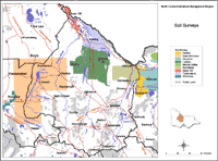
The map on the right shows these areas and can be clicked on to go to relevant information.

Over 25 soil surveys have been carried out which cover parts of the North Central region. To find details about these surveys and their availability from DEDJTR libraries access the Soil and Land Survey Directory.
Page top