Ferrosols
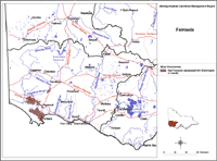
Ferrosols are soils which lack strong texture contrast between surface (A) horizons and subsoil (B) horizons. They are also characterised by high free iron and clay contents. They are not common in the region and are mainly restricted to minor occurrences in the Branxholme Basalt Land Unit.
| Ferrosols in the Glenelg-Hopkins Region This broad scale map presents an overview and should only be used as a general indication of the distribution of Ferrosols in the Glenelg-Hopkins Region. It shows areas where Ferrosols are most likely to occur within the region. Note that other soil types may also occur within these mapped areas, although they are likely to be a more minor component. | |
| This map has been developed from work done as part of the Glenelg-Hopkins Land Resource Assessment project in 1999-2001. This work utilised existing surveys, remote sensing information and additional field work to develop an updated 1:100 000 soil/landform coverage across the region. Soils are difficult to map at this broad scale because of their diversity. Even in relatively small areas, a number of soils may occur which relate to differences in topography and landscape position. Variation in some of the major soil profile properties can also occur within these mapped areas. Any agricultural enterprise should be based on a proper on-site assessment of the soil and landscape. |
A number of soil surveys have been completed in this region at varying scales and intensity. However, in some areas very little soil survey has taken place so see the Soil and Land Survey Directory.


