Mechanisms that drive dryland salinity
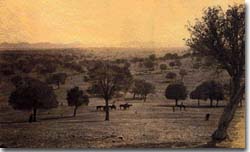
| The most commonly used explanation for the development of dryland salinity relates to deep-rooted, perennial, native vegetation being replaced with shallow rooted, introduced vegetation - ie. annual crops. Consequent reduction in evapotranspiration and water interception allows more water to move through the soil profile to the groundwater (ie. recharge). This results in a rise in water levels, and stored salt is mobilised to the surface, via capillary rise, forming a salt crust. Development of dryland salinity model - before and after clearing: |  Picture of the Stavely Hills taken in 1865, with the eastern section of the Grampians showing in the distance. Source: Ken Brain. |
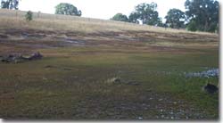
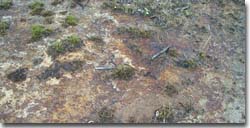
While this model is not wrong, there are very few situations in nature where this model can be applied, as groundwater/surface water flow through the landscape is rarely homogeneous, isotropic and uniform. Rather, highly complex and dynamic examples of such regions within the Glenelg-Hopkins Catchment Management Region include Willaura, the Dundas Tablelands and the Grampians. Research conducted by Jonathan Fawcett as a part of his PhD studies at Marriefields, northern region of the Eastern Dundas Tablelands, found that;
| "Clearing of native vegetation has exposed discharging springs and saturated soils to the mechanical damage by grazing. Subsequently the permeability and soil stability of the discharge zones has been decreased by erosion and the mobilisation and subsequent precipitation of Fe and Sulphur rich compounds. Chemical processes impedes the ability of the seep to discharge, forcing discharging water from the fractured rock spring to discharge around the seep. Clearing has created an environment where a cycle of chemical reactions further enlarge the discharge zones and accelerate erosion." (Fawcett, J., et al,1999) |
Dahlhaus et. al. (2002) further asserts that the phenomenon of dryland salinity in the Glenelg-Hopkins region is unique for the following reasons:
· evidence for significant primary salinity as opposed to man-induced secondary salinisation e.g. Willaura catchment, Dundas Tablelands
· a suggestion that watertables across SW Victoria are naturally high
· that the expression of secondary salinisation is plausibly related to alterations in surface drainage that has resulted in the loss of a natural dilution factor.
· post-European hydrological change has significantly increased lateral groundwater throughflows in some landscapes (e.g. Dundas Tablelands)
It is clear that many of the groundwater systems in SW Victoria are near full saturation and in pseudo-equilibrium, so that groundwater fluctuations tend to ebb and flow with climatic variation. Willaura is a classic example of a system that is now largely climatically driven (Heislers, 2001).
 Discharge area in eastern Dundas Tablelands (photo: CLPR) |  Close up of discharge area (photo: CLPR) |
Dryland salinity – more complex than originally thought!
Victoria’s salinity program “Salt Action: Joint Action” was launched in 1987, under which the Glenelg Regional Salinity Strategy (GSF, 1993) was prepared.
The focus of the Strategy was to control groundwater recharge, as this was thought to be the primary cause of salinity. The Strategy advocated the broad-scale replacement of low productivity pastures dominated by annual species with pastures based on perennial grasses and legumes as a means of reducing groundwater recharge and controlling dryland salinity. Dryland salinity management has focused largely on attempts to reverse changes in the hydrologic balance following agricultural development. Much effort towards understanding the relationships between soils, rainfall, vegetation and farming systems has aimed to identify productive land management practices that use more rainfall, whilst limiting runoff and groundwater recharge. Some of these issues have been explored in the Willaura catchment.
There is a recognition now that effective recharge control is generally difficult to justify economically in the large regional groundwater flow systems (eg. Basalt Plains). Such systems require regional scales of adoption for recharge control to be effective; and the outcomes may not be delivered for many decades due to the built-in inertia and slow responsiveness of these systems. In such circumstances stabilising and/or increasing the productivity of groundwater discharge areas may be the only practical option.
We now know that ameliorating salinity is more than simply recharge control. Salinity management requires a holistic approach to landscape water control. Catchments are unique so it cannot be assumed that we can simply translate our understanding of one particular landscape to others. Just as there is no single landscape and groundwater process responsible for the development of dryland salinity, there can be no single management remedy. The manifestation of salinity in each region is linked intimately to the groundwater processes prevailing within that region, and relationships with regional landscapes. Only when these relationships are understood can informed salinity management planning occur.
Inferring salinity risk on the basis of catchment character involves understanding regional geology, regional geomorphology (landscapes), the impacts of climate, and the function and processes which influence groundwater flow in the region of concern. In part, the risk of dryland salinity depends on the nature of these groundwater flow systems within each catchment. Risk depends, to a large extent, on the size of the aquifers, how readily they transport groundwater, and their storage capacity based on the materials that comprise them. Risk is a function of how long the aquifer will take to fill. The key to developing sensible dryland salinity management strategies lies with understanding how landscapes and groundwater processes function to cause salinity. With this knowledge we can contemplate how we might achieve salinity outcomes through simple prescriptions based on our understanding of landscapes and the processes that operate therein (Coram J., et al. 1999).


