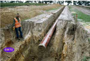
SW70
|
| SW70 | 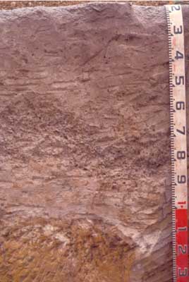 Humose, Sesquic, Semiaquic PODOSOL | |
| Irrewillipie road, south of Underwoods road, south of Colac | |||
| Undulating low hills | |||
| Neogene Hanson Plain Sand, Palaeogene Dilwyn Formation | |||
| Waxing upper slope | |||
| 5% | |||
| West | |||
Horizon | Depth (cm) | Description | ||
Ap | 0–20/25 | Very dark greyish brown (10YR3/2 moist), greyish brown (10YR5/2 dry); loamy sand; apedal structure; pH 5.3; diffuse boundary to: | ||
A2 | 30–90/110 | Greyish brown (10YR5/2 moist), conspicuously bleached (10YR7/2 dry); sand; sporadic gravel band (>100 mm); with dark very medium to coarse (5-15 mm) nodules with manganiferous centres; very weak to weak consistence; pH 5.4; abrupt boundary to: | ||
B21s | 90/110–150 | Brown (7.5YR4/4 moist and dry) and brownish yellow (10YR6/8 moist) to yellow (10YR7/8 dry); sandy clay loam; cemented sand, (‘coffee rock’) massive structure; firm to strong consistence; clear boundary to: | ||
B22g | 150–200 | Yellowish brown (10YR5/8 moist) (50%) and light greenish grey (5GY7/1 moist) (50%); very dark greyish brown (10YR3/2 moist) coatings; sandy light clay; pH 6; clear boundary to: | ||
B23 | 200 + | Mottled yellowish brown (10YR5/8 moist) (30%) and light greenish grey (5GY7/1 moist) (70%); sandy light clay; apedal structure.
| ||
| Management considerations | ||||
| This deep sandy soil is very acidic and has poor chemical fertility. The soil lacks peds and is likely to be hard setting when dry and ‘spewy’ and weak when wet. The water holding capacity of this soil is low but the cemented B horizon will tend to hold up water and prevent excessive vertical drainage of the profile. This soil will become compact under animal and vehicular traffic and is vulnerable to wind or water erosion if left bare (e.g. when cultivated). | ||||
Analytical data
Site SW70 | Sample depth | pH | EC | NaCl | Ex Ca | Ex Mg | Ex K | Ex Na | Ex Al | Ex acidity | FC (-10kPa) | PWP (-150kPa) | KS | FS | Z | C | |
Horizon | cm | H2O | CaCl2 | dS/m | % | cmolc/kg | cmolc/kg | cmolc/kg | cmolc/kg | mg/kg | cmolc/kg | % | % | % | % | % | % |
A1 | 0–10 | 5.3 | 4.6 | 0.25 | N/R | 2 | 1.1 | 0.44 | 0.72 | 15 | 9.9 | 15.1 | 6.8 | 48.9 | 32.3 | 9 | 5 |
A2 | 30–50 | 5.4 | 4.6 | 0.07 | N/R | 0.27 | 0.13 | <0.05 | 0.18 | 11 | 2.1 | 8.2 | 1.2 | 47.8 | 38.3 | 8 | 4.5 |
B21s | 65–85 | 5.8 | 4.9 | 0.08 | N/R | 1.3 | 1.9 | 0.09 | 0.33 | <10 | 4.1 | 12 | 6 | 45.8 | 31.8 | 3.5 | 17.5 |
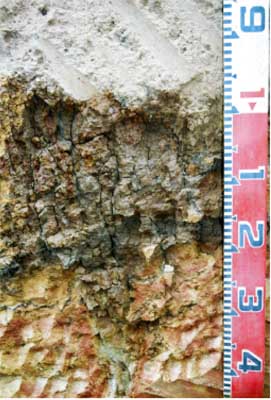 | 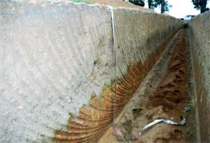 | 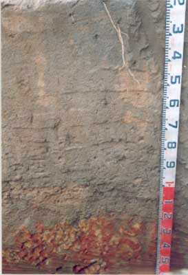 |
Contrasting soils upslope from SW70 showing deep sandy profile over ferruginised (iron-enriched) sedimentary parent material; profile with thin sodic clay B horizon at 1 metre (left), trench cutting (centre), profile with no clay B horizon and no ironstone gravel (right) | ||

