Soil and Landform Mapping
The information provided here has been developed from the project "A Land Resource Assessment of the Corangamite Region" by Robinson et al. (2003). This project was undertaken within the former Department of Primary Industries, for the Corangamite Catchment Management Authority. It utilised existing surveys such as Maher and Martin 1987 and Pitt 1981, remote sensing information and additional field work to develop an updated 1:100 000 scale soil/landform mapping coverage across the region. A number of soil surveys have been previously completed in this region at varying scales and intensity. Details about these surveys can be found in the Soil and Land Survey Directory on this website.
 |
A Land Resource Assessment of the Corangamite Region - October 2003 (PDF - 4984 KB) A Land Resource Assessment of the Corangamite Region - October 2003 (DOC - 2906 KB) To view the information PDF requires the use of a PDF reader. This can be installed for free from the Adobe website (external link). Soil Group and Associated Soil Pits |
|
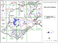
Over 200 soil/landform units have been defined for the region. Each soil/landform unit described includes photographs of the general landscape as well as 3-D block diagrams and topographic section profiles. For each soil/landform unit, there are appropriate soil sites that are considered good examples of soil types that can occur in these units. The map on this page enables you to click onto a 1:100 000 map sheet of interest and bring up the soil/landform map as well as a listing of soil/landform units, soil groups and geomorphic units that occur on each sheet. |
Access to spatial data
A spatial dataset of Land units of the Corangamite region of Victoria (DOI 10.4226/92/58e7149507e74) is freely available through the DataVic website.
References
Maher, J.M. and Martin, J.J. (1987). Soils and Landforms of South-Western Victoria. Part 1. Inventory of Soils and their Associated Landscapes. Research Report Series No. 40. Department of Agriculture and Rural Affairs.
Pitt, A.S. (1981). A Study of the Land in the Catchments of the Otway Ranges and Adjacent Plains. Tech. Comm. #14. Soil Conservation Authority.
Robinson, N; Rees, D; Reynard, K; MacEwan, R; Dahlhaus, P; Imhof, M; Boyle, G and Baxter, N (2003). A Land Resource Assessment of the Corangamite Region. Department of Primary Industries.


