SW23
|
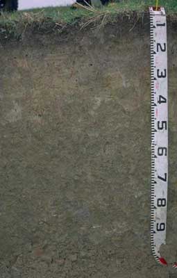
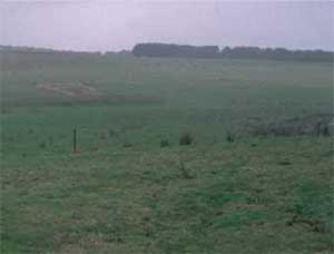
| SW23 |  Acidic, Mesotrophic, Brown DERMOSOL | |
| Simpson | |||
| Undulating hills | |||
| Tertiary-Moorabool Viaduct Formation. | |||
| Lower slope | |||
Horizon | Depth (cm) | Description | ||
A1 | 0-10 | Dark brown (10YR3/3); fine sandy clay loam; weak consistency (moist); pH 5.6; abrupt boundary to: | ||
A2 | 10-25 | Light brownish grey (10YR6/2); rusty root channel mottling present; silty clay loam; weak coarse blocky structure; pH 5.4; clear boundary to: | ||
B1 | 25-40 | Light yellowish brown (2.5Y6/4) with reddish yellow (7.5YR6/6) mottles; heavy silty clay loam; weak to moderate coarse blocky structure; pH 5.2; clear boundary to: | ||
B21 | 40-70 | Brown (10YR5/3) with reddish yellow (7.5YR6/6) mottles; silty clay; moderate coarse blocky, parting to strong medium polyhedral structure; pH 5.0; clear boundary to: | ||
B22 | 70+ | Light brownish grey (10YR6/2) with brownish yellow (10YR6/6) mottles; light medium clay; weak very coarse prismatic, parting to strong coarse blocky and strong fine to medium polyhedral structure; pH 5.0. | ||
Analytical data
Site SW23 | Sample depth | pH | EC | NaCl | Ex Ca | Ex Mg | Ex K | Ex Na | Ex Al | Ex acidity | FC (-10kPa) | PWP (-150kPa) | KS | FS | Z | C | |
Horizon | cm | H2O | CaCl2 | dS/m | % | cmolc/kg | cmolc/kg | cmolc/kg | cmolc/kg | mg/kg | cmolc/kg | % | % | % | % | % | % |
A1 | 0-10 | 5.6 | 4.9 | 0.15 | N/R | 5.4 | 1.1 | 0.2 | 0.1 | N/R | N/R | 36.4 | 13 | 5 | 43 | 25 | 16 |
A2 | 10-25 | 5.4 | 4.6 | 0.1 | N/R | 1.9 | 0.8 | 0.3 | 0.05 | N/R | N/R | 25.6 | 8 | 2 | 50 | 30 | 16 |
B1 | 25-40 | 5.2 | 4.3 | 0.11 | N/R | 1.7 | 1.3 | 0.3 | 0.1 | N/R | N/R | 26.9 | 10.6 | 2 | 47 | 26 | 25 |
B21 | 40-70 | 5 | 4.2 | 0.13 | N/R | 1.8 | 1.8 | 0.3 | 0.2 | N/R | N/R | 28.5 | 13.1 | 2 | 42 | 26 | 30 |
B22 | 70+ | 5 | 4.2 | 0.15 | N/R | 2.2 | 3.9 | 0.3 | 0.3 | N/R | N/R | 30.5 | 16.5 | 1 | 35 | 21 | 42 |


