
IS21
Location: Horsham
Morphological Soil Type: Bungalally Clay
Australian Soil Classification: Episodic-Endocalcareous, Epipedal, Grey VERTOSOL
Northcote Factual Key: Ug 5.24
Great Soil Group: grey clay
Mapping Unit: Bungalally Clay.
General Landscape Description: Lake and lunette plain.
Site Description: Cleared and cultivated area. Playa plain.
Geology: Late Pleistocene to Holocene, lacustrine deposition. Quaternary Coonambidgal Formation: fluvial to lacustrine clays and sands
Native Vegetation: Original vegetation probably Black Box (Eucalyptus largiflorens).
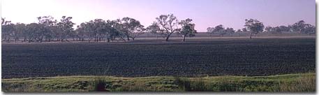
| IS21 Landscape. Lunette in the back ground and lake in the middle and fore ground. |
Soil Profile Morphology:
Surface Soil
| A1 | 0-20 cm | Dark grey (10YR4/1); light medium clay; subplastic; cracking and self-mulching surface condition; moderate angular blocky structure; very strong consistence dry, slightly sticky consistence wet; pH 7.5; sharp and smooth change to: | 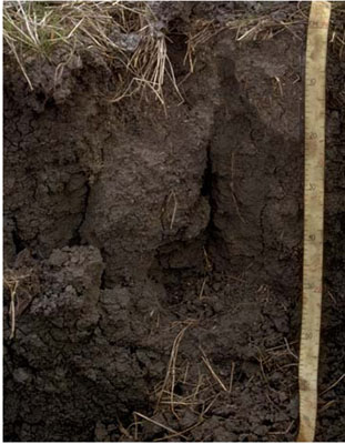 IS21 Profile |
| Subsoil | |||
| B21 | 20-30 cm | Dark grey (10YR4/1); light clay; subplastic; strong very coarse prismatic structure; strong consistence dry, slightly sticky consistence wet; pH 8.2: | |
| B22 | 30-65 cm | Dark grey (10YR4/1); heavy clay; plastic; strong very coarse prismatic structure; strong consistence dry, slightly sticky consistence wet; pH 8.3; gradual change to: | |
| B23 | 65-135 cm | Grey (10YR5/1); heavy clay; plastic; moderate angular blocky structure; very strong consistence dry, slightly sticky consistence wet; contains very few (< 2 %) hard carbonates; pH 8.5; gradual change to: | |
| B24 | 135-190 cm | Grey (10YR5/1); medium clay; plastic; moderate angular blocky structure; very strong consistence dry, slightly sticky consistence wet; pH 9.2. | |
Key Profile Features:
- High clay content throughout soil profile.
- The soil cracks significantly when dry.
- Vertic properties (ie. significant shrink-swell characteristic).
Soil Profile Characteristics:
pH | Salinity Rating | |||
Surface (A1 horizon) | Slightly Alkaline | Low | Sodic | Slight1 |
Subsoil (B21 horizon) | Moderately Alkaline | Low | Sodic | Slight1 |
Deeper Subsoil (at 1 m) | Moderately Alkaline | Medium-High | Strongly Sodic | Strong |
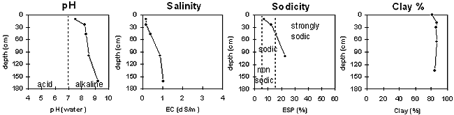
| The surface soil is slightly alkaline. The subsoil is moderately alkaline. | The salinity rating is low in the surface and upper subsoil becoming high with depth. | The surface and upper subsoil is sodic becoming strongly sodic with depth. | The clay content is high throughout the profile. |
Chemical and Physical Analysis:
Horizon | Sample Depth cm | pH H2O | EC dS/m | Sodium Chloride % | Exchangeable Calcium cmol-/kg | Exchangeable Magnesium cmol-/kg | Exchangeable Potassium cmol-/kg | Exchangeable Sodium cmol-/kg | Total Nitrogen % | Organic Carbon % | Exchangeable Acidity cmol-/kg | Bulk Density | Permanent Wilting Point -1500okPa | Coarse Sand % | Fine Sand % | Silt % | Clay % |
A1 | 0–20 | 7.5 | 0.19 | 0.02 | 19.8 | 10.5 | 3.5 | 2.6 | 0.18 | 2.0 | 9.6 | 0.96 | 30.2 | 1 | 11 | 5 | 81 |
B21 | 20–30 | 8.2 | 0.2 | 0.02 | 20.6 | 11.5 | 3.5 | 5 | 0.12 | 1.49 | 8.2 | 1.17 | 35.5 | 1 | 5 | 5 | 87 |
B22 | 30–65 | 8.3 | 0.41 | 0.07 | 19.1 | 11.3 | 3.5 | 6.5 | 0.1 | 0.76 | 7.1 | 1.13 | 33.7 | 1 | 7 | 3 | 86 |
B23 | 65–135 | 8.5 | 0.88 | 0.18 | 13.9 | 12.8 | 3.5 | 8.8 | 0.05 | 0.25 | 5.7 | 1.19 | 33.5 | 1 | 8 | 4 | 87 |
B24 | 135–190 | 9.2 | 1.03 | 0.21 | 35.0 | 1 | 6 | 4 | 84 |
Management Considerations:
Whole Profile
- Plant available water capacity (PAWC) is considered to be moderate (estimated at 140 mm). This is based on available laboratory data and assumes an effective rooting depth of 65 cm. The effective rooting depth will be restricted in the strongly sodic deeper subsoil which has a medium to high salinity rating.
Surface (A) Horizon
- The surface soil is sodic and disperses strongly after remoulding. This indicates that structural degradation (eg. surface sealing, increased cloddiness) may occur if the soil is cultivated or overstocked in a moist to wet condition. Also, raindrop action on bare surface soil may also promote dispersion and result in surface sealing or surface crust formation. Surface cover should be maintained to protect against raindrop damage. The use of gypsum may assist in ameliorating the surface soil.
- When the soil is dry, heavy rains will move down soil cracks. This rapid recharge can be valuable for the survival of plants near wilting. When wet, the soil will swell and further infiltration of water will be relatively slow.
- Tillage of cracking clay soils should be avoided when the soil is wetter than the plastic limit. At such a moisture condition, excessive tillage, trafficking or overstocking may result in soil structural damage (eg. compaction, smearing) occurring. Ideally, tillage and trafficking should take place when the soil is drier than the plastic limit, down to at least the tillage depth.
- The high wilting point value (ie. 30 %) indicates that plants will be unable to utilise light rains when the soil is relatively dry.
Subsoil (B) Horizons
- The coarsely structured upper subsoil is sodic and disperses slightly. This is likely to restrict root and water movement somewhat. The relatively high level of exchangeable calcium relative to magnesium in the upper subsoil will probably have a beneficial effect on soil structure.
- Strong dispersion occurs in the upper subsoil after remoulding. This indicates that disturbance to this horizon during tillage when the soil is wet will result in structural degradation occurring.
- The level of soluble salts becomes medium to high in the deeper subsoil (from 65 cm depth). At these levels, the growth of salt sensitive species (eg. faba beans, linseed, chick peas, lupins) may be restricted.
Profile Described By: John Martin, Nabil Badawy, Ron Cawood, Geoff Pope, John Galea, John Turner (1970).
Reference: "Major Agricultural Soils of the Wimmera Irrigation Area". John Martin, Mark Imhof, Lourey Ruth, Rob Nink, Karen DePlater, Paul Rampant, Sonia Thompson, S. Alexander. Department of Natural Resources and Environment, Victoria. 1996.
© State of Victoria (Agriculture Victoria) 1996 - .

This work, Victorian Resources Online, is licensed under a Creative Commons Attribution 4.0 licence. You are free to re-use the work under that licence, on the condition that you credit the State of Victoria (Agriculture Victoria) as author, indicate if changes were made and comply with the other licence terms.
The licence does not apply to ‘branding’ or some ‘images or photographs’ that may be owned by third parties. We ask you to seek prior approval to use images using the VRO feedback form. Access to higher quality images can also be provided on request.
This page was last updated on .