
Soil/Landform Unit - Tallageira swampy sand plains
Landform Unit Description
Page top
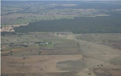 Eastern extent of an east-west sandy plain near Bringabert |
0.87% of CMA region This unit of low relative relief terrain consists of a major and minor occurrence north of Apsley on the South Australian border. This linear dunes subdivision (5.2.2) falls within the North West Dunefields and Plains siliceous dunefields. This dunefield and sand plain complex of Quaternary Lowan Sand (aeolian sediments) is a parallel feature of the Little Desert to the north. It is flanked to the north and south by plains as well as ridge topography. Dunefields and gently undulating plains are co-dominant. Soils are sandy (generally without a pan) within dunefields, and yellow grey sodic texture contrast soils (Sodosols) are found on the plains and local depressions. Sheet, wind and rill erosion are land degradation issues given the light sandy texture of the topsoils. Grazing (sheep, beef cattle) with occasional dryland cropping and nature conservation are major land uses. Remnant vegetation includes a number of communities found on damp sand or poorly drained soils. Plains Woodland, Damp Sands Herb-rich Woodland/Shallow Sands Woodland Mosaic, Damp Sands Herb-rich Woodland, Drainage-line Woodland, Plains Sedgy Woodland and Seasonally Inundated Shrubby Woodland occur here. | 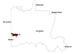 |
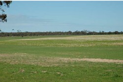 Sand component of swampy sand plain with remnant vegetation and improved pastures | 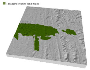 |
 | 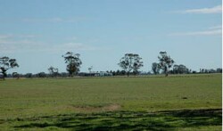 Sheep grazing on a swampy sand plain |
Component | 1 | 2 |
Proportion of soil-landform unit | 50% | 50% |
| CLIMATE Rainfall (mm) | Annual: 555 | |
| Temperature (oC) | Minimum 8, Maximum 21 | |
| Precipitation less than potential evapotranspiration | October–March | |
| GEOLOGY Age and lithology | Quaternary paludal silt and clay | |
| Geomorphology | 5.2.2 Linear dunes of the Siliceous North West Dunefields and Plains | |
| LANDUSE | Uncleared areas: hardwood forestry for sawlogs, posts and poles; nature conservation Cleared areas: sheep and beef cattle grazing; dryland cropping; nature conservation | |
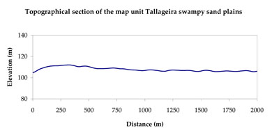
| TOPOGRAPHY Landscape | Swampy sand plains | |
| Elevation range (m) | 97–158 | |
| Local relief (m) | 2-3 | |
| Drainage pattern | Dendritic–deranged | |
| Drainage density (km/km2) | 0.2 | |
| Landform | Dunefields and plains | |
| Landform element | Dunefield | Gentle undulating plain |
| Slope and range (%) | 5 (1-10) | 2 (1-5) |
| Slope shape | Straight | Convex |
| NATIVE VEGETATION Ecological Vegetation Class | Plains Woodland (31.6%), Shallow Sands Woodland (13.9%), Shallow Sands Woodland/Plains Sedgy Woodland/Seasonally Inundated Shrubby Woodland/Damp Sands Herb-rich Woodland Mosaic (10.3%), Damp Sands Herb-rich Woodland (10.2%), Other (33.8%) | |
| SOIL Parent material | Aeolian sand | Marine sand and silt, paludal silt and clay |
| Description (Corangamite Soil Group) | Sandy soils with and without pans (31) | Sodic yellow and grey texture contrast soils (32) |
| Soil type sites | ||
| Surface texture | Sand | Loamy sand |
| Permeability | High | Slow to moderate |
| Depth (m) | > 1.5 | > 1.5 |
| LAND CHARACTERISTICS, POTENTIAL AND LIMITATIONS Critical land features, processes, forms | Soils with low organic matter levels can be susceptible to wind and sheet erosion where exposed. Low inherent soil fertility. | Susceptible to wind and sheet erosion where exposed. Low inherent fertility but well drained to pans or subsoil. Susceptible to compaction where hardsetting and poor drainage occurs. |
© State of Victoria (Agriculture Victoria) 1996 - .

This work, Victorian Resources Online, is licensed under a Creative Commons Attribution 4.0 licence. You are free to re-use the work under that licence, on the condition that you credit the State of Victoria (Agriculture Victoria) as author, indicate if changes were made and comply with the other licence terms.
The licence does not apply to ‘branding’ or some ‘images or photographs’ that may be owned by third parties. We ask you to seek prior approval to use images using the VRO feedback form. Access to higher quality images can also be provided on request.
This page was last updated on .