
Soil/Landform Unit - Surridge foothills
Landform Unit Description
Page top
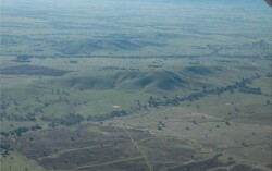 Footslopes that feed Six Mile and Seven Mile creeks near Concongella |
0.25% of CMA region Footslopes of rises, low hills and plains surround the Concongella hills east of Stawell. On the southern Wimmera CMA boundary, the slopes form part of the Dissected Western Uplands. These rises, low hills and plains of predominantly Palaeozoic metasediments and derived sediments flank the Concongella hills. This unit is also bound by colluvial deposits and alluvial systems of Six Mile and Seven Mile creeks. Upper and mid slopes of low hills are prominent, along with lower slopes, rises and drainage depressions. Drainage dissects this landscape, concentrating flow from this unit and the higher hills/steeper slopes increasing the susceptibility to gully erosion. Red texture contrast soils (generally sodic) are the main soil type with yellow sodic texture contrast soils (Sodosols) found on the lower slopes and flats (less drainage). These units are used for grazing (sheep, beef cattle), with occasional dryland cropping on the flats and lower slopes. Remnant vegetation communities recorded include Heathy Dry Forest, Grassy Dry Forest, Alluvial Terraces Herb-rich Woodland, Creekline Grassy Woodland and Grassy Woodland. |  |
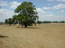 Undulating plaisn and rises with yellow box remnants | 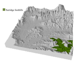 |
 | 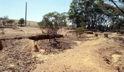 Gully and tunnel erosion on steeper slopes |
Component | 1 | 2 | 3 | 4 |
Proportion of soil-landform unit | 45% | 30% | 10% | 15% |
| CLIMATE Rainfall (mm) | Annual: 630 | |||
| Temperature (oC) | Minimum 7, Maximum 19 | |||
| Precipitation less than potential evapotranspiration | October–April | |||
| GEOLOGY Age and lithology | Cambrian marine sandstone, siltstone and biotite schist (St Arnaud Group); Quaternary fluvial gravel, sand and silt | |||
| Geomorphology | ||||
| LANDUSE | Uncleared areas: nature conservation Cleared areas: sheep and beef cattle grazing; dryland cropping | |||
| TOPOGRAPHY Landscape | Undulating rises, foothills and footslopes | |||
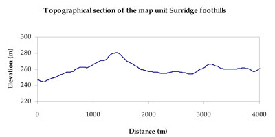
| Elevation range (m) | 219–353 | |||
| Local relief (m) | 35–40 | |||
| Drainage pattern | Dendritic | |||
| Drainage density (km/km2) | 1.7 | |||
| Landform | Foothills and footslopes | Undulating rises | Drainage depressions | |
| Landform element | Moderate to gentle upper slope | Gentle lower slope | Crest | Drainage line |
| Slope and range (%) | 7 (3-20) | 4 (2-15) | 3 (0-7) | 2 (0-15) |
| Slope shape | Convex | Linear | Convex | Concave |
| NATIVE VEGETATION Ecological Vegetation Class | Grassy Woodland (64.1%), Alluvial Terraces Herb-rich Woodland (15.4%), Heathy Dry Forest (9.4%), Other (9.1%) | |||
| SOIL Parent material | Marine sandstone, siltstone and biotite schist, intrusive granite and granodiorite | Marine sandstone, siltstone and biotite schist, intrusive granite and granodiorite | In situ marine sandstone, siltstone and biotite schist | Fluvial gravel, sand and silt |
| Description (Corangamite Soil Group) | Red texture contrast soils (1) | |||
| Soil type sites | ||||
| Surface texture | Sandy loam | Sandy loam | Fine sandy loam | Sandy loam |
| Permeability | Moderate | Moderate | Moderate to high | Slow |
| Depth (m) | 1.2 | 1.5 | 0.7 | 1.5 |
| LAND CHARACTERISTICS, POTENTIAL AND LIMITATIONS Critical land features, processes, forms | Soils may be friable with better infiltration in moister areas, hardsetting and more prone to sheet and rill erosion in drier aspects. Sodic subsoil prone to gully and tunnel erosion. Susceptible to acidification in wetter areas. | Soils may be friable with better infiltration, some surfaces are hardsetting and more prone to sheet and rill erosion. Sodic subsoil prone to gully and tunnel erosion. Susceptible to acidification in wetter areas. | Friable with better infiltration in moister areas, hardsetting and more prone to sheet and rill erosion in drier areas (north and westerly aspects). Susceptible to acidification in wetter areas. | Soils may be friable with better infiltration, some surfaces are hardsetting and more prone to sheet and rill erosion. Sodic subsoil prone to gully and tunnel erosion. Susceptible to acidification in wetter areas. |
© State of Victoria (Agriculture Victoria) 1996 - .

This work, Victorian Resources Online, is licensed under a Creative Commons Attribution 4.0 licence. You are free to re-use the work under that licence, on the condition that you credit the State of Victoria (Agriculture Victoria) as author, indicate if changes were made and comply with the other licence terms.
The licence does not apply to ‘branding’ or some ‘images or photographs’ that may be owned by third parties. We ask you to seek prior approval to use images using the VRO feedback form. Access to higher quality images can also be provided on request.
This page was last updated on .