
Soil/Landform Unit - Mount Dryden metamorphic hills
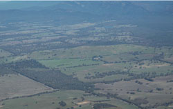 Looking south over Mount Dryden |
0.09% of CMA region This unit of hilly terrain consists of a number of relatively small discreet hills that form a discontinuous arc east of the Grampians Ranges, mainly on the eastern side of Mt William Creek. Part of the hills and valley slopes of the Dissected Western Uplands, this hilly terrain of Cambrian volcanics is surrounded by alluvial plains of Mount William Creek as well as occasional colluvial and older sedimentary rises and hills. These hills are pronounced in the low terrain of this major geocol. Upper hillslopes, ridges and gentle footslopes all occur with mainly radial drainage away from the hills. The rock is quite hard with rock outcrop often found on the crests and slopes with soil depth varying accordingly (deeper on the lower slopes). Soils are predominantly red sodic texture contrast soils with yellow, brown and grey sodic texture contrast soils (Sodosols) occurring on lower slopes and minor depressions. Shallow gradational soils occur on the upper slopes. Grazing is the major enterprise (sheep and cattle) and a quarry operates to produce road metal from the hard rock. Vegetation communities found on well-drained soils include Heathy Woodland, Plains Grassy Woodland and Shrubby Woodland. | 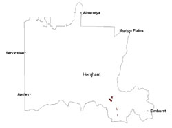 |
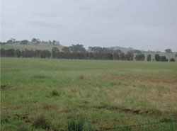 Revegetated low hills near Jallukar | 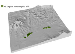 |
 | 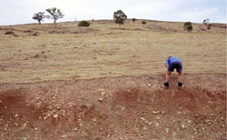 Cutting on slopes of Mount Dryden |
Component | 1 | 2 | 3 |
Proportion of soil-landform unit | 15% | 65% | 20% |
| CLIMATE Rainfall (mm) | Annual: 690 | ||
| Temperature (oC) | Minimum 8, Maximum 19 | ||
| Precipitation less than potential evapotranspiration | October–March | ||
| GEOLOGY Age and lithology | Cambrian ‘greenstone’ - basalt, andesite, boninite, rhyolite, gabbro, lithic sandstone, chert, shale and breccia; Quaternary alluvium, silt, sand and gravel | ||
| Geomorphology | |||
| LANDUSE | Uncleared areas: nature conservation Cleared areas: sheep and beef cattle grazing; dryland cropping; viticulture | ||
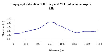
| TOPOGRAPHY Landscape | Metamorphic hills | ||
| Elevation range (m) | 180–294 | ||
| Local relief (m) | 40–80 | ||
| Drainage pattern | Dendritic | ||
| Drainage density (km/km2) | 0.7 | ||
| Landform | Hills | ||
| Landform element | Ridge | Upper hillslope | Lower footslope |
| Slope and range (%) | 6 (3-10) | 25 (20-50) | 5 (3-15) |
| Slope shape | Convex | Convex | Concave |
| NATIVE VEGETATION Ecological Vegetation Class | Plains Grassy Woodland (56.4%), Heathy Woodland (18.9%), Hills Herb-rich Woodland (5.7%), Other (12.3%) | ||
| SOIL Parent material | Intrusive and extrusive basalt, andesite, rhyolite and gabbro | Intrusive and extrusive basalt, andesite, rhyolite and gabbro | Colluvial gravel, sand and silt |
| Description (Corangamite Soil Group) | Red texture contrast soils (1) | Sodic red texture contrast soils (2) | |
| Soil type sites | |||
| Surface texture | Fine sandy loam | Sandy loam | Sandy loam |
| Permeability | Moderate | Moderate | Moderate to slow |
| Depth (m) | < 0.5 | 0.7 | 1.5 |
| LAND CHARACTERISTICS, POTENTIAL AND LIMITATIONS Critical land features, processes, forms | Friable with better infiltration in moister areas, hardsetting and more prone to sheet and rill erosion in drier areas (north and westerly aspects). Susceptible to acidification in wetter areas. | Soils may be friable with better infiltration in moister areas, hardsetting and more prone to sheet and rill erosion in drier areas (including drier aspects). Sodic subsoil prone to gully and tunnel erosion. Susceptible to acidification in wetter areas. | Light loose surface soils susceptible to wind, sheet and rill erosion in drier areas (including drier aspects). Sodic subsoil susceptible to gully erosion. Poor subsurface drainage, particularly on gentle slopes. Surface soils susceptible to acidification. |
© State of Victoria (Agriculture Victoria) 1996 - .

This work, Victorian Resources Online, is licensed under a Creative Commons Attribution 4.0 licence. You are free to re-use the work under that licence, on the condition that you credit the State of Victoria (Agriculture Victoria) as author, indicate if changes were made and comply with the other licence terms.
The licence does not apply to ‘branding’ or some ‘images or photographs’ that may be owned by third parties. We ask you to seek prior approval to use images using the VRO feedback form. Access to higher quality images can also be provided on request.
This page was last updated on .