
Soil/Landform Unit - Grampians plains
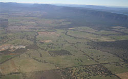 View of the eastern extent of the Grampians Range with prominent outwash slopes and long gentle plains grading away from the range |
1.33% of CMA region The Grampians plains soil-landform unit surrounds the Grampians Range as narrow zones of siliceous sand derived from outwash of the weathering and erosion from the range. Footslopes are characterised by gently undulating plains that graduate into plains with scattered drainage lines. Plains scattered amongst plains and lower and in topographic sequence away from the ranges. Soils are mostly deep and are dominated by brown and yellow texture contrast soils with sandy surfaces (Sodosols) that are quite variable in depth. Long gentle slopes are subject to periodic inundation and waterlogging during wet seasons. While the light sandy surfaces are generally well drained, they have extremely dense heavy subsoils that inhibit deeper water infiltration. Soils are typically acidic with low inherent fertility surface soils. There are a number of vegetation communities present including woodlands, forests and a number of complex and mosaic vegetation formations. Some of the more common vegetation communities include sandy heathlands, forests, shrubland and woodlands. |  |
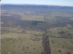 Looking across Mount William Creek towards the plains | 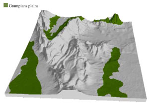 |
 |  Sandy plains at Moyston West |
Component | 1 | 2 | 3 |
Proportion of soil-landform unit | 1% | 49% | 50% |
| CLIMATE Rainfall (mm) | Annual: 860 | ||
| Temperature (oC) | Minimum 7, Maximum 19 | ||
| Precipitation less than potential evapotranspiration | October–March | ||
| GEOLOGY Age and lithology | Quaternary alluvium, gravel, sand and silt; Neogene marine sand, sandstone, silt, laterite (Dorodong Sand); Quaternary colluvium, alluvium, gravel, sand and silt | ||
| Geomorphology | |||
| LANDUSE | Uncleared areas: water supply; nature conservation Cleared areas: sheep grazing; viticulture; olive plantations; residential development; native flowers; stone fruit; dryland cropping | ||
| TOPOGRAPHY Landscape | Colluvial outwash slopes | ||
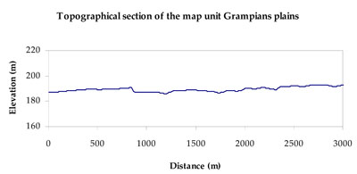
| Elevation range (m) | 149–748 | ||
| Local relief (m) | 2 | ||
| Drainage pattern | Parallel–dendritic | ||
| Drainage density (km/km2) | 1.1 | ||
| Landform | Gently undulating plains | ||
| Landform element | Drainage line | Undulating footslope | Gently undulating plain |
| Slope and range (%) | 3 (1-7) | 5 (3-10) | 2 (1-6) |
| Slope shape | Concave | Concave | Straight |
| NATIVE VEGETATION Ecological Vegetation Class | Heathy Woodland (13.9%), Rocky Outcrop Herbland (7.6%), Shrubby Woodland (7.5%), Riparian Shrub (5.8%), Other (63.5%) | ||
| SOIL Parent material | Alluvial gravel, sand and silt | Colluvial sand, silt and minor gravel | Marine laterite sand and silt, colluvial sand and silt, aeolian dune sand |
| Description (Corangamite Soil Group) | Brown and yellow texture contrast soils (sandy surfaces) (17) | Brown and yellow texture contrast soils (sandy surfaces) (17) | Brown and yellow texture contrast soils (sandy surfaces) (17) |
| Soil type sites | |||
| Surface texture | Sandy loam | Sandy loam | Sandy loam |
| Permeability | Moderate | Moderate | Moderate |
| Depth (m) | > 2 | > 2 | > 2 |
| LAND CHARACTERISTICS, POTENTIAL AND LIMITATIONS Critical land features, processes, forms | Flat areas subject to inundation and waterlogging, susceptible to gully erosion where sodic subsoil is exposed. Light sandy surface soils generally well drained to subsoil or hardpan. Weakly coherent surfaces with little organic matter are susceptible to sheet and wind erosion where exposed. Acidic, low inherent fertility surface soils. | Susceptible to gully erosion where sodic subsoil is exposed. Light sandy surface soils generally well drained to subsoil or hardpan. Weakly coherent surfaces with little organic matter are susceptible to sheet and wind erosion where exposed. Acidic, low inherent fertility surface soils. | Long gentle slopes are subject to periodic inundation and waterlogging. Light sandy surface soils generally well drained to heavy subsoil. Weakly coherent surfaces with little organic matter are susceptible to sheet and wind erosion where exposed. Soil may be susceptible to compaction. Acidic, low inherent fertility surface soils. |
© State of Victoria (Agriculture Victoria) 1996 - .

This work, Victorian Resources Online, is licensed under a Creative Commons Attribution 4.0 licence. You are free to re-use the work under that licence, on the condition that you credit the State of Victoria (Agriculture Victoria) as author, indicate if changes were made and comply with the other licence terms.
The licence does not apply to ‘branding’ or some ‘images or photographs’ that may be owned by third parties. We ask you to seek prior approval to use images using the VRO feedback form. Access to higher quality images can also be provided on request.
This page was last updated on .