
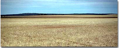
Soils of the Neuarpur area
Intermittent Swamps | Little Desert | Lunettes | Permanent Waterbodies | Sand Plains and Rises | Southern Cracking Clay Plains | Yellow Gum Plains and Rises | Neuarpur Soil Index
The soils and landform of this area was mapped in 1997 as part of a report on the ‘Agricultural and Horticultural Suitability for the West Wimmera Shire’ by N.M Baxter et al. Agriculture Victoria, Department of Natural Resources and Environment. |
 |
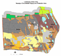 Neuarpur Groundwater Supply and Protection Area | The Land Units mapped as part of this study identify areas of land on the basis of similar geology, slope and soil types. Mapping was carried out at a 1:100 000 map scale which necessitated some generalisation. Users should exercise caution when interpreting map information as it presents a guide only as to the likely soil types in an area. In any one area soils can vary significantly according to landscape, geology and management. Any agricultural enterprise should be based on a proper on-site assessment of the soil and landscape. |
Reference
Lowan Land Inventory and Assessment, Land Systems and Land Management Options. M. Imhof, S. Thompson & D. Rees, Dept. of Natural Resources and Environment. March 1997.
© State of Victoria (Agriculture Victoria) 1996 - .

This work, Victorian Resources Online, is licensed under a Creative Commons Attribution 4.0 licence. You are free to re-use the work under that licence, on the condition that you credit the State of Victoria (Agriculture Victoria) as author, indicate if changes were made and comply with the other licence terms.
The licence does not apply to ‘branding’ or some ‘images or photographs’ that may be owned by third parties. We ask you to seek prior approval to use images using the VRO feedback form. Access to higher quality images can also be provided on request.
This page was last updated on .