
Sand Plains and Rises
Landscape
This land system has been separated from the Red Gum Plains and Rises Land System. However, the soils commonly have the similar ‘ironstone’ pan above the clay due to the deeper depth of sand deposits above the ferruginised gravel pan. The vegetation commonly indicates distinct changes from the deeper sand and the shallow sand. As with most units in the region, the plains and rises are divided by clay plains that are often drainage depressions.
The land system in the Neuarpur area has been divided into two land units:
- gently undulating plain
- gently undulating plain (closer spaced undulations)
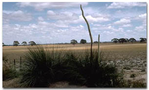 Sand plain in the Kaniva Region. |
Native Vegetation
The major tree species is Brown Stringybark with an understorey of heath vegetation, such as Grass Trees and Tea Trees.
Soil Types
The most common soil type on the three land units within this Land System is a sandy topsoil over mottled strongly acidic clay. The depth of surface sand is variable, often deeper than 50 cm and can be as deep as two metres in some areas. There is often a gravel layer of mainly ferruginised iron nodules, although ferruginised manganese and indurated sandstone can also occur over a mottled clay subsoil. Clay skins and slickensides may occur in the subsoil, indicating that significant shrinking and swelling of the clay occurs during wetting and drying cycles. The gravel layer is not always present, although the presence of the deep deposit of hydrophobic sand over the clay is consistent with the soils in these units. These soils are referred to as Bleached-Ferric, Yellow Kurosols. Site WW26 is a representative soil profile for this Land System but is not located within the Neuarpur Groundwater Management Area.
Another soil type occurring on this unit is a Podosol (Site WW75). This soil often has a deep layer of sand overlying a ‘coffee rock’ (a horizon high in organic-aluminium and iron compounds which overlies a mottled subsoil).
The third soil type occuring in this Land System is a Sodosol (Site WW14). These soils are typified by variable depths of surface sand overlying a clayey subsoil which is sodic.
Current Land Use
Much of this area is designated public land, and any freehold land is generally left vegetated and used for minimal grazing. Pinus radiata is often grown on these sandy soils. Potatoes are also grown in some areas.
© State of Victoria (Agriculture Victoria) 1996 - .

This work, Victorian Resources Online, is licensed under a Creative Commons Attribution 4.0 licence. You are free to re-use the work under that licence, on the condition that you credit the State of Victoria (Agriculture Victoria) as author, indicate if changes were made and comply with the other licence terms.
The licence does not apply to ‘branding’ or some ‘images or photographs’ that may be owned by third parties. We ask you to seek prior approval to use images using the VRO feedback form. Access to higher quality images can also be provided on request.
This page was last updated on .