
Yellow Gum Plains and Rises
Landscape
This land system consists mostly of gently undulating plains and undulating plains (closer spaced undulations) with small rises and long gentle slopes. There are also areas of undulating rises (closer spaced undulations) that have slightly higher relief than the surrounding plains. Within this unit there may also occur small areas of low lying land (or drainage depressions) with soils similar to the southern cracking clay plains. Gently undulating plains may occur between the rises. There are common indications of gilgai micro-relief, as the subsoil tends to shrink and swell at depth, but little evidence of surface cracks.
This unit is difficult to separate from the Red Gum plains and rises. The landscape is similar and the Ferric Sodosols can occur in association with this soil type (eg. south east of Goroke). In these areas, Sodosols with coarse columnar structure in the upper subsoil are dominant (Site WW12). This unit occurs mostly between the Little Desert and Edenhope.
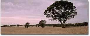 Isolated Yellow Gums. |
Vegetation
The main tree species is Yellow Gum although there are occurrences of Red Gum.
Soil Types
The dominant soils on these units have the distinctive conspicuously bleached capping over large hardsetting clay columns or prisms in the upper subsoil. A sandy or sandy loam topsoil occurs above the capping to varying depths. Similar soils also occur in the transitional country of the Big and Little Deserts. Grey Vertosols (Site WW12) tend to occur on the lower part of slopes and in flatter areas. Brown (Site WW11) and Red Sodosols can occur on higher parts of slopes. Site WW12 is used as the representative soil profile for the mapping unit.
The hardsetting nature of the bleached capping and the large hardsetting structure of the clay makes direct penetration difficult for roots through to the subsoil. Many roots follow the cracks between the column blocks.
The plants also have difficulty accessing the nutrients held tightly in the clay columns. The clay is sodic (high sodium content) making the soil strongly dispersive resulting in structural breakdown in water. The bleached horizon (A2) and the mottled subsoil are indicators of impeded internal drainage. Soils on the top of the crests may have Parilla Sandstone occurring at depth.
© State of Victoria (Agriculture Victoria) 1996 - .

This work, Victorian Resources Online, is licensed under a Creative Commons Attribution 4.0 licence. You are free to re-use the work under that licence, on the condition that you credit the State of Victoria (Agriculture Victoria) as author, indicate if changes were made and comply with the other licence terms.
The licence does not apply to ‘branding’ or some ‘images or photographs’ that may be owned by third parties. We ask you to seek prior approval to use images using the VRO feedback form. Access to higher quality images can also be provided on request.
This page was last updated on .