
Koonwarra (Ko)
- Koonwarra and Koonwarra, sand overlay (Ko:Ko,s)
- Koonwarra and Strzelecki (Ko:Sz)
- Koonwarra, sand overlay (Ko,s)
- Koonwarra with Strzelecki (Ko/Sz)
| Geology Mesozoic sediments (Cretaceous) - consisting of sandstones, siltstones and mudstones. Landform Undulating hills. The slopes are mostly gently inclined (3-10%) with small areas of moderate slopes (10-32%). This mapping unit occurs on the down-throw side of the faults and monoclines. It is less dissected than the Strzelecki unit. |  |
Land Use
Mostly plantation forestry but smaller areas are used for grazing - predominantly beef and dairy cattle.
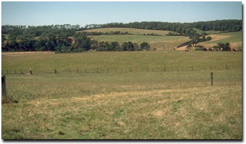
Typical undulating hills landscape of the Koonwarra unit near Fish Creek.
Soils
Component 1
Most of this mapping unit is described as gently inclined slopes. The surface soils are generally brownish-grey to grey-brown fine sandy loams to fine sandy clay loams. Below about 20 cm the soil is generally lighter in colour and often conspicuously bleached or sporadically bleached. Yellowish-brown and grey-brown mottled medium clays occur abruptly from about 30 to 50 cm and often the ped faces in the upper part of this horizon are darkly stained by organic matter. Bedrock generally occurs between 1 and 2 m (Site SG7 and Site SG11 are examples of Brown Kurosols that occur in this unit). In areas close to the coast, the subsoils may become slightly sodic and these soils are referred to as Sodosols. Site GP51 is an example of a Sodosol that occurs near Dalyston.
Component 2
This is a minor component that occurs on the steeper slopes. The soils are similar to those described in the previous mapping unit and have grey-brown clay loam surface soils, grading into yellowish grey-brown clay loams or light clays at about 35 cm. At 60 cm, greyish yellow-brown light clay or occasionally medium clays are encountered. These become yellow-brown with light brownish grey mottles with depth. Fragments of rock generally appear by about 80 cm and continue until about 1.2 m when rock becomes impenetrable.
Occurrences
This mapping unit is associated with the low hills around Wonthaggi and Koonwarra.
© State of Victoria (Agriculture Victoria) 1996 - .

This work, Victorian Resources Online, is licensed under a Creative Commons Attribution 4.0 licence. You are free to re-use the work under that licence, on the condition that you credit the State of Victoria (Agriculture Victoria) as author, indicate if changes were made and comply with the other licence terms.
The licence does not apply to ‘branding’ or some ‘images or photographs’ that may be owned by third parties. We ask you to seek prior approval to use images using the VRO feedback form. Access to higher quality images can also be provided on request.
This page was last updated on .