
Strzelecki (Sz)
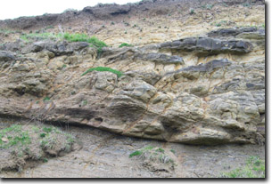 Cretaceous sediments in road cutting. | 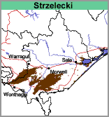 |
Geology
Cretaceous sediments (sandstone, siltstone and mudstone).
Landform
Rolling hills. The slopes are mostly moderate (10-32%) with some areas having steep slopes (32-56%).
The area is regarded as a strongly dissected upland that resulted from a series of uplifts dating from the Tertiary period, continuing spasmodically until the present day.
Land Use
In the western Strzeleckis the major land use is grazing, predominantly beef and dairy cattle. Smaller, but increasing areas are being used for plantation forestry. In the eastern Strzeleckis, north of Foster, the predominant land use is forestry.
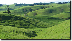
Rolling hills landscape near Leongatha
Soils
The texture of the soils is largely dependent on the nature of the sediments from which they were derived with mudstones forming more clayey soils than those derived from sandstones. Aspect and past erosional history also play a part. Often less clayey and shallower soils are found on the northerly to westerly slopes.
Component 1
Most of the soils on slopes have dark greyish-brown or brown clay loam surface soils which grade into yellowish grey-brown clay loams or light clays at about 35 cm. At 60 cm, pale greyish brown or pale brown light clay or medium clays are encountered which become yellow-brown mottled with light brownish grey with depth. Fragments of rock generally appear by about 80 cm and continue until about 1.2 m when rock becomes impenetrable. Soil Site SG5, Site SG6 and Site SG12 are examples of Brown and Grey Dermosols that occur within this unit. In the Mount Worth area the soils can be darker in colour and have higher clay contents (see Soil Pite Site CFTT1 - an example of a Black Dermosol near Mt. Worth East).
Component 2
On the lower colluvial slopes and on the broad crests there is generally a sharper separation between the grey-brown clay loam or fine sandy clay loam surface soil and the mottled light brownish grey and yellow-brown light or medium clay subsoil, that occurs from about 50 cm. The bedrock occurs much deeper.
Component 3
On the narrow flats associated with the drainage lines the soils are derived from locally derived alluvium and colluvium. The surface soils are grey-brown fine sandy clay loams to clay loams commonly grading into mottled grey-brown and yellow-brown light clays at depth.
Component 4
On some of the steeper northern-facing slopes the soils can be quite shallow and have minimal soil profile development. Soil Site GP52 is an example of a shallow Tenosol near Bass Hill.
Occurrences
This mapping unit occurs extensively throughout South Gippsland.
© State of Victoria (Agriculture Victoria) 1996 - .

This work, Victorian Resources Online, is licensed under a Creative Commons Attribution 4.0 licence. You are free to re-use the work under that licence, on the condition that you credit the State of Victoria (Agriculture Victoria) as author, indicate if changes were made and comply with the other licence terms.
The licence does not apply to ‘branding’ or some ‘images or photographs’ that may be owned by third parties. We ask you to seek prior approval to use images using the VRO feedback form. Access to higher quality images can also be provided on request.
This page was last updated on .