
GP51
| Location: Dalyston. | Australian Soil Classification: Eutrophic, Mottled-Subnatric, Black SODOSOL |
| Geology: Cretaceous sediments. | General Landscape Description: Upper mid slope (8%) (easterly aspect) of a rolling hill. |
| Soil Mapping Unit: Koonwarra | |
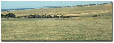 Site GP51 Landscape |
Soil Profile Morphology:
Surface Soil
| A1 | 0-15 cm | Very dark greyish brown (10YR3/2); clay loam fine sandy; moderate coarse subangular blocky, parting to strong fine polyhedral, and fine subangular blocky structure; very firm consistence dry; pH 5.7; clear change to: | 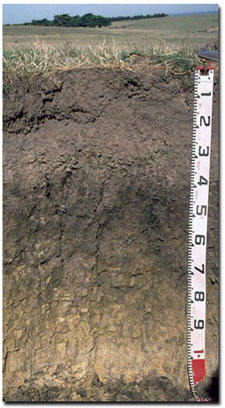 Site GP51 Profile |
| A2 | 15-35 cm | Greyish brown (10YR5/2) conspicuously bleached (10YR7/2d); clay loam fine sandy; root channel mottling present; moderate subangular blocky, parting to weak fine polyhedral structure; very firm to strong consistence dry; contains a few (2%) subrounded manganese (< 5 mm in size) segregations; pH 6.0; clear and wavy change to: | |
| Subsoil | |||
| B21 | 35-55 cm | Very dark greyish brown (10YR3/2) with few (10%) brownish yellow (10YR6/6) mottles; heavy clay; strong coarse prismatic, parting to moderate coarse prismatic, parting to moderate coarse angular polyhedral structure; strong consistence dry; smooth faced peds; pH 6.1; gradual change to: | |
| B22 | 55-85 cm | Light olive brown (2.5Y5/4) with brownish yellow (10YR6/6) and dark greyish brown (10YR4/2) mottles common (10-20%); medium heavy clay; more plastic than clay above; strong coarse prismatic, parting to moderate coarse blocky structure; pH 6.6; gradual change to: | |
| C | 85-100+ cm | Weathered sediments. | |
Key Profile Features:
- Strong texture contrast between surface (A1) horizon and subsoil (B21) horizon.
- A sporadic bleach occurs occasionally within the subsurface (A2) horizon.
Horizon | pH | Salinity Rating | ||
Surface (A1 horizon) | Moderately Acid | Low | Non-Sodic | __ |
Subsoil (B21 horizon) | Slightly Acid | Very Low | Marginally Sodic | None |
Deeper subsoil (at 80 cm) | Slightly Acid | Very Low | Sodic | None |
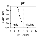 | 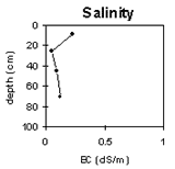 | 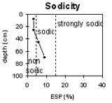 | 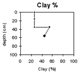 |
The surface soil is moderately acid. The subsoil is slightly acid. | The salinity rating in the surface soil is low becoming very low in the subsoil. | The surface soil is non-sodic. The subsoil is sodic. | The clay percentage increases markedly at the A/B boundary. |
Horizon | Horizon Depth (cm) | pH water | pH CaCl2 | EC 1:5 | Exchangeable Cations | Ex. Al mg/kg | Ex. Acidity meq/100g | Wilting Point pF 4.2 | Coarse Sand (0.2 - 2.0 mm) | Fine Sand (0.02-0.2 mm) | Silt (0.002-0.02 mm) | Clay (<0.002 mm) | |||
Ca | Mg | K | Na | ||||||||||||
meq/100g | |||||||||||||||
A1 | 0-15 | 5.7 | 5.1 | 0.22 | 7.8 | 3.6 | 0.79 | 0.71 | <10 | 14 | 17.7 | 4 | 28 | 32 | 36 |
A2 | 15-35 | 6 | 4.9 | 0.05 | 1.6 | 4.2 | 3.4 | 0.2 | <10 | 11 | 11.4 | 4 | 35 | 31 | 25 |
B21 | 35-55 | 6.1 | 5 | 0.09 | 7.2 | 12 | 0.59 | 1.8 | 16 | 10 | 24.5 | 1 | 22 | 18 | 54 |
B22 | 55-85 | 6.6 | 5.6 | 0.12 | 5.8 | 13 | 0.39 | 2.4 | <10 | 6.5 | 21.4 | 1 | 35 | 19 | 45 |
Management Considerations:
Surface (A) Horizons
- The presence of conspicuous bleaching and root channel mottling in the subsurface (A2) horizon indicates that periodic waterlogging occurs above the more slowly permeable subsoil.
- The upper subsoil is dense and coarsely structured which will result in restricted root and water movement.
© State of Victoria (Agriculture Victoria) 1996 - .

This work, Victorian Resources Online, is licensed under a Creative Commons Attribution 4.0 licence. You are free to re-use the work under that licence, on the condition that you credit the State of Victoria (Agriculture Victoria) as author, indicate if changes were made and comply with the other licence terms.
The licence does not apply to ‘branding’ or some ‘images or photographs’ that may be owned by third parties. We ask you to seek prior approval to use images using the VRO feedback form. Access to higher quality images can also be provided on request.
This page was last updated on .